


Good morning, Central Coast! Happy Monday!
As we kick off a new work week, low lying cloud cover is filtering in, this will make for some dense fog for parts of the region this morning. Critically though, this is more low cloud than marine layer, thankfully keeping many beaches clear from fog. As you raise in elevation that fog is still expected but will be patchy. Wherever you are, be aware of limited visibility this morning.

The dense cloud cover moving into the region this morning includes the potential of a few pockets of mist/drizzle/light showers this morning. This will be limited at best but still worth noting.
Monday is all about the transition into a new air mass and the atmosphere prepping for the bulk of the system that is expected Tuesday, Wednesday and Thursday.
We have been waiting for this pattern shift for quite a while, now that it is significantly closer I feel good about taking much more stock in the high resolution model outputs that we have now.
The cooler air and onshore flow associated with the trough will drive low clouds into the coast through Monday. As the trough continues to dig the surface low-pressure features will start to provide mist and drizzle at first with the thick marine influence but then some real showers begin early Tuesday with more robust rain Tuesday through Thursday.
The high resolution models are just starting to come in, here is how the storm timing is looking.
Tuesday morning scattered showers will begin and stay on and off through evening. There is enough energy and vorticity (spin) in these storms that there is the risk of thunderstorms. The Storm Prediction Center has portions of the Central Coast under a marginal risk of thunderstorms for Tuesday. Despite only the northern half of the Central Coast is within this risk I think that everyone has the risk and should be aware.

Wednesday the majority of the storm will move in with consistent rain through the day. This is where the bulk of the rain will come from.
By Thursday conditions will return to scattered showers as the low ejects east.
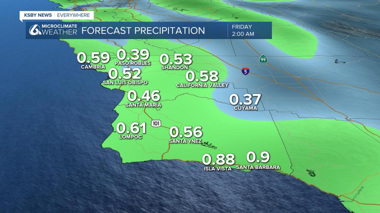
In terms of how much rain is possible: I think "up to 1 inch" is a good broad-brush expectation. Most locations will be between 0.4" and 0.75" of rain. The current track of the low is critical. If it moves closer to us, the rain totals may increase substantially.
Winds will also be out of the SW on Tuesday and Wednesday, and some gusts past 30 or 35mph are possible, especially Wednesday. Don’t be surprised if some wind advisories are posted for this system.
Highs all week to be in the 50s and lower 60s as the entire area is under the trough influence.
I think the trough exits Thursday with Friday thru the weekend likely being dry, but it does appear another upper-level low spins in the region to keep temps from any fast rebound.
This is a forecast where the details are certain to change quickly and more advisories are certainly possible, so please stay tuned this week.
Have a great day Central Coast!
