


How this article works:
To keep everything organized you can find a few vital quick reference links at the top, followed by the active alerts and most recent updates throughout the day from Meteorologists Vivan Rennie and Dave Hovde. Further down will be more supporting information. If there is a conflict of information the newest information at the top should be considered the more accurate.
Important links:
Alerts:
Update from KSBY Meteorologist Dave Hovde 12:20am:
The advisory situation has changed. The flash flood warning has been allowed to expire but flood advisories and a flood watch continue. Here is the latest on the revised advisories:
Update from KSBY Meteorologist Dave Hovde 10:43pm:
The lull in activity is not perfect, some showers are still going on. We'll see less activity until we get into Monday afternoon when a second surge of activity is expected. We could still see some areas getting more rain measured in inches. There is still a minor thunderstorm threat Monday. Flood warnings continue until 12am, a wind warning for Santa Barbara County Mountains continues til 4am. Some advisories are dropping. Even though rain may not be hammering down, the standing and moving water can still be dangerous and people are advised to use caution.
My latest thoughts on the forecast are included in the forecast video from our 10pm show.
Update from KSBY Meteorologist Dave Hovde 8:19pm:
Rainfall has increased in the area of most concern of the forecast: southern Santa Barbara County. Rainfall totals for the storm system range between 2 inches to 11 inches in the mountains above the south coast. We are not done with rainfall from the system yet there will be another round of moderate to heavy rain later Monday into Tuesday. Between now and then on and off showers and downpours are likely but more off than on.
Considering the amount of rain we've already received there are numerous advisories in place including a flood warning for all of Santa Barbara county, and a good portion of San Luis Obispo county. The area in San Luis Obispo county, not covered by. The warning is covered by an aerial flood advisory. The only difference between the two is the severity of the flooding taking place.
Wind gust today did reach the 60 to 80 mph range. The high wind warning for much of the area has been replaced by a wind advisory through 10 PM but a high wind warning remains in the Santa Barbara county mountains.
I talk about that in the video pinned to the top of the story.
Update from KSBY Meteorologist Dave Hovde 5:26pm:
An Areal Flood Advisory has been added to portions of SLO County not already covered in the Flash Flood Warning:
Flash Flood Warning issued for Santa Barbara and part of SLO County until 12am.

Between 0.5 and 1 inch of rain has fallen. Additional rainfall amounts of 1 to 4 inches are possible. Flash flooding is ongoing or expected to begin shortly.
Flash flooding of small creeks and streams, urban areas, highways, streets and underpasses as well as other poor drainage and low-lying areas.
Update to coastal flood advisory: Dave Hovde, KSBY Meteorologist 2:36pm
**interesting note with this advisory that coastal flooding impacts could be continuous into Monday morning's high tide.
Flood advisories updated: Dave Hovde, KSBY Meteorologist 2:17pm
SLO County is in a flood advisory until 5pm: Between 0.5 and 1 inch of rain has fallen. Additional rainfall amounts of 1 to 2 inches are expected over the area through 500 PM. Flood advisory extended for Santa Barbara County until 4pm (could be extended later)
High Wind Warning
All of San Luis Obispo and Santa Barbara Counties through 10 p.m. it is extended through 6 a.m. Monday morning along our South Coast Communities. Sunday night Southeast to South winds 30-50 mph with damaging gusts between 70 and 80 mph are expected. Localized gusts up to 90 mph are possible on exposed peaks and canyons. This level of winds are expected to cause damage. Downed trees and power lines are expected.

If you are curious about the peak wind gusts so far. The link in this post will take you to a text report listing them. Yes, we have seen 70+mph gusts.
Areal Flood Watch
All of San Luis Obispo and Santa Barbara counties through Tuesday night. Flooding is expected as excessive rainfall continues to be possible through Tuesday. The worst of which is expected along the Santa Barbara County South Coast and highest ridges. Debris flows and mudslides are possible especially around recent burn scars. Creeks and streams may rise out of their banks.

Coastal Flood Advisory
All Central Coast beaches and tidal locations through 9 a.m. Monday. Minor to moderate coastal flooding expected near high tide (4:30 a.m.) Sunday morning for Port San Luis, Avila Beach, Oceano and Cayucos.

High Surf Advisory
All Central Coast beaches through 9 p.m. Monday. Large breaking waves with dangerous rip currents. South Facing beaches 14 to 18 ft with localized sets up to 20 ft. Peaking Tuesday

Marine Storm Warning
All outer waters off the Central Coast. Southeast winds 30 to 40 kt with gusts up to 55 kt combined with 14-19ft swells expected until 6 p.m. Sunday Evening. Mariners should remain in port and take extreme caution.

Storm Updates:
1 p.m. Update from Meteorologist Vivian Rennie
12:15 p.m. Update from Meteorologist Vivian Rennie
A flood advisory has been issued for the Santa Barbara County south coast and Santa Ynez Mountains through 2 p.m. this afternoon due to heavy rain. Minor flooding is already occurring in some spots and more rain is expected. Shallow rockslides and mudslides are possible as well as water over roadways and flooding.
10:15 a.m. Update from Meteorologist Vivian Rennie
Winds are continuing to strengthen across the Central Coast. Thankfully they are expected to calm down a bit by this afternoon.
Original Sunday Morning Article from Meteorologist Vivian Rennie
Pockets of heavy rain are falling across the Central Coast but the winds are the focus this morning. Widespread gusts upwards of 45 mph and localized gusts upwards of 60 mph have already occurred and will get more intense as we progress through Sunday morning. Passes, peaks and canyons are expected to see some gusts up to 90 mph today. There is a high wind warning in place through 10 p.m. for these damaging winds. Power outages are expected.

I know the rain isn't falling particularly hard right now but more is on the way. The strong winds, heavy rain and overall atmospheric setup is categorized as a 3/5 atmospheric river. Here is a little more detail on that!

Rainfall will pick up significantly later on this morning into Sunday afternoon, that is expected to bring inches of rain across the state, the worst of it along the Santa Barbara County South Coast. There the strong southerly winds will help with additional energy so this storm could force upwards of 5 inches at the peaks of the Santa Ynez mountains.

Heavy rain will move in to the Central Coast later this morning and will last into Tuesday. Because of this the Weather Prediction Center has extended Excessive Rainfall Outlooks to all of the Central Coast. The South Coast into the LA Basin is at the highest risk for flooding with all a High Risk, Coastal Valleys and most of the rest of the region is under a Moderate Risk with interiors under a Slight risk.

Here are some rivers we'll have to monitor during the event:
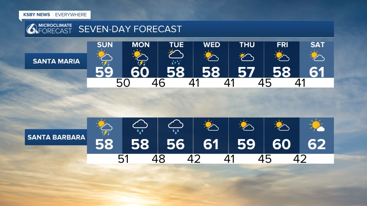
Looking into the "normal" parts of our weather articles, here is a look at your extended forecast!

Please be safe outside through this storm. Conditions will change rapidly.
