


The way this story works. New information is at the top with older information further down the story.
———9:00 p.m. Update from Meteorologist Dave Hovde———
Rain has ended for most of the Central Coast. Interestingly, despite the flood advisories none of the reporting stations we use regularly got over 1" of rain. I do have some viewer reports of 1" rainfall in places like Santa Maria but I think the general rule was this was less-than-an-inch rain for most.
Flood advisories are dropped. Only the surf advisories remain and those don't even go into effect until tomorrow morning.
———4:53 p.m. Update from Meteorologist Dave Hovde———
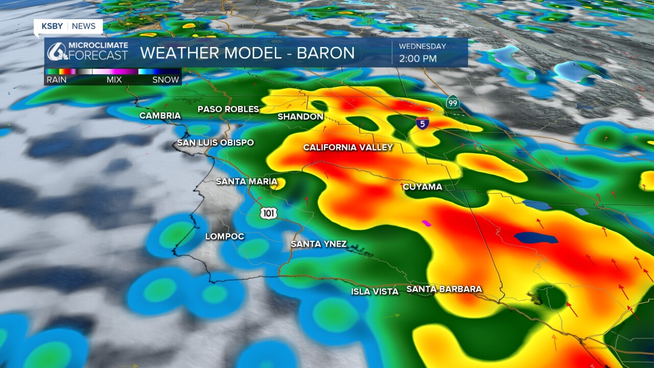
The storm system is showing some signs of weakening as the low pressure center is tumbling to our south. The further away the low migrates the weather the dynamics are.
That said, the system is continuing to drop rainfall across the area. Rain in northern SLO County is beginning to end, or at least taper off. We always expected the system to produce lighter amounts north and more for Santa Barbara County. That appears to be the case. AG and south we see more .50"+ rainfall totals. North of the 5 Cities the totals have been lower. We will post rainfall amounts once the system is done (or mostly done).
I'm going to include some advisories here near the top. I'll just mention that both counties are in area flood advisories until 8pm.
This is for saturated ground and locally strong downpours capable of producing minor flooding.
There is a winter weather advisory for the Santa Barbara County Mountains until the system departs. At the highest elevations 2-8" of snow is possible but only a dusting down to 4500ft.
Surf advisories go into effect Thursday morning and last until Friday morning.
Models today have been hedging about a Sunday front capable of producing some light showers, there is another front next week which also brushes the area. Right now, I'm not convinced these are much to write home about. So, I'll mention it here but leave it out of the official forecast until indications are stronger.
———2:15 p.m. Update from Meteorologist Vivian Rennie———
Due to the heavy rain pushing through the flood advisory has been extended to include San Luis Obispo County and the rest of Santa Barbara County.

Heavy rain is creating the risk for minor flooding and landslide development. Take caution Central Coast!

———1:30 p.m. Update from Meteorologist Vivian Rennie———
A flood advisory has been issued for Southeast Santa Barbara County through 8 p.m. tonight due to excessive rainfall. Low lying and poor drainage areas will experience minor flooding due to these storms.

———12:55 p.m. Update from Meteorologist Vivian Rennie———
Another Special Weather Statement has been issued, this time for Morro Bay, Cayucos as well as Baywood-Los Osos. Through 1:30 p.m. a strong thunderstorm will bring gust up 55 mph, dangerous lightning, pea sized hail, heavy downpours and a very small chance for tornadoes.

———12:45 p.m. Update from Meteorologist Vivian Rennie———
As expected a line of strong storms has formed offshore and is poised to create a tricky afternoon. In anticipation of the heavy rain, hail and flooding concern a Special Weather Statement has been issued for all of Western and Southern Santa Barbara County (where I have circled in red) although similar conditions are expected for all of the Central Coast.
Through 3 p.m. strong storms will bring gust up 50 55 mph, dangerous lightning, hail, heavy downpours and a very small chance for tornadoes. Stay weather aware today.

——— Original Article——-
Good morning Central Coast!
Jumping right in, we have significant rain on the way today with showers, thunderstorms, winds and potential winter weather through the day today. Be sure to stay weather aware today as these storms begin.
Here is a look at your interactive radar.
To start off this morning a few strong thunderstorms are occurring across our waters. This has prompted a special marine warning for the waters off of the Central Coast. This is sue to a few strong rotating thunderstorms that are capable of producing waterspouts, hail and locally strong winds. A this point the risk is mainly for mariners but as the day goes on the showers will push onshore.
Special Marine Warning including the Waters from Pt. Sal to Santa Cruz Island CA and westward 60 nm including San Miguel and Santa Rosa Islands, Point Piedras Blancas to Point Sal from 10 to 60 NM and Point Piedras Blancas to Point Sal westward out to 10 NM until 8:45 AM PST pic.twitter.com/KLgL1cIv94
— NWS Los Angeles (@NWSLosAngeles) March 6, 2024
The storm this warning is for is a good warning bell for the thunderstorm risk later on today. Embedded in the storm will be a few cells that have more energy within them and capability to produce hail, strong winds and once again a small tornado risk. I would be surprised if the storm held together enough as it pushes onshore for that to be a concern but it is not out of the question.
Timing wise showers are limited to start off, mainly with the storms offshore becoming more intense through the mid day hours as the front and core low pressure move onshore.
The heaviest rain will move in in a band right along the cold front driving this system. That will get here by lunchtime and pass quickly to the east.

By mid afternoon the heaviest rain band will have pushed into the interior valleys, while the coasts will clear out!
By evening the heavy rain will have moved on but there is still a few scattered showers still on the way. This will come as the core low pressure moves in and brings in some "wrap around moisture" to the region. This will be much lighter than the afternoon rain but still something to keep in mind.

As far as rainfall totals go there will be a lot of variability tanks to the embedded thunderstorms. Interior valleys will see the least but still up to half an inch. Elsewhere most communities will pick up half to a full inch of rain. Most will be near 0.75".

It is a fast-mover. Thursday the rain is gone, high pressure builds again and the rest of the forecast remains dry with slowly warming temps, climbing from the low 60s today to 70 by Friday.


Have a great day Central Coast! Be sure to stay weather aware!
