Good morning, Central Coast!
To kick off the week we are seeing something that isn't particularly common, completely clear skies. A strong offshore high pressure system is helping to push significant winds from the interiors west (opposite of the usual pattern) and banishing the marine layer and making for a beautiful start to the day.

The clear morning and skyrocketing temps are all thanks to a large high pressure system sitting offshore. This ridge of high pressure is the driving force for our forecast as it continues to bring clear skies, and offshore winds. This combination is making for a very hot day throughout the region.
Offshore winds are a major factor today as high pressure air is pushed from the already warm interiors towards the coast. As the elevation falls towards the coast the air is compressed and thus heated up. The offshore winds will falter slightly this afternoon and allow some onshore breeze to develop but it will be weak and isolated at best. Very little impact to high temps is expected from that change. The one thing the onshore shift will do is allow for a northerly component of the winds to kick in and will make for another sundowner wind event along the Santa Barbara County western southcoast.
Gusts as strong as 45 mph are possible this evening near the Gaviota coastline. This is enough that a wind advisory has been issued for that area through 3 a.m. Tuesday morning.

More offshore winds are expected Tuesday before calming slightly later this week.
Despite the highest temps occurring in the interiors the high temps across the coasts and beaches are also significantly higher than normal for this time of year.
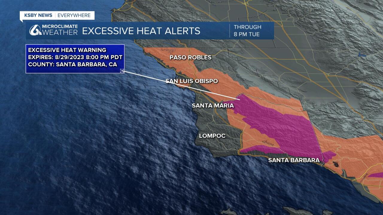
There is a heat advisory in place for much of the coastal valleys and the western portions of the interior valleys for today and Tuesday. Additionally there is an excessive heat warning in place for the Santa Barbara County interiors. These are both in place through 8 p.m. Tuesday.

Even if you aren't included in these alerts stay aware of the extreme heat. Please take common sense precautions as we continue to see extreme heat!
Temperatures along the Santa Ynez Valley will be reaching the upper 90s on Monday, while the interior valley will see temps in the upper 90s and up to 105 degrees. Even temps near the beaches will be up to 10 degrees above normal for this time of year.

By Tuesday night into Wednesday morning a low pressure will move south and kick the high pressure we are facing out of the region. This trough of low pressure will reverse winds back to their typical onshore pattern and help to reestablish the marine layer over coastal regions. This will significantly cool the region to the point that temps will fall below normal for this time of year by the weekend.
Have a wonderful Monday, Central Coast! Don't forget to download the KSBY Microclimate Weather App for all your latest weather headlines.


