

As the Gifford Fire continues to spread, firefighters are facing some of the most difficult conditions on California’s Central Coast, not because of extreme weather or wind, but because of where the fire is burning.
The blaze is now established deep inside the San Rafael Wilderness, a federally protected stretch of steep, remote, brush-covered terrain east of Santa Maria. Fire officials say once flames enter this kind of landscape, all the usual tools — bulldozers, control lines, road access — are no longer options.
“Unfortunately, the fire is already established in the San Rafael Wilderness,” said Flemming Bertelsen, Public Information Officer for Los Padres National Forest. “There’s just a lack of fuel breaks and no roads and wilderness areas by definition, just no opportunities really to come up with a viable control line on that south end.”
Bertelsen says crews had initially hoped to prevent the fire from entering the wilderness altogether. But without natural breaks or containment barriers, the southern edge is now extremely difficult to manage.
“One of our primary objectives early on was to keep it out of that wilderness,” he said. “Because once it’s established there, it’s even, there’s a higher level of complexity altogether just trying to contain it on that south side.”
That southern stretch of the forest is not only remote, but ecologically and culturally sensitive. According to Bertelsen, it’s home to the Sisquoc River, a federally designated Wild and Scenic River, along with a range of endangered species and historically significant sites.
“There’s a wild and scenic river in there called the Sisquoc River,” he said. “And, you know, it’s a rich ecosystem for Chumash cultural artifacts as well as threatened and endangered species, and we’ve got the wildlife resources, and it’s just a viable watershed altogether.”
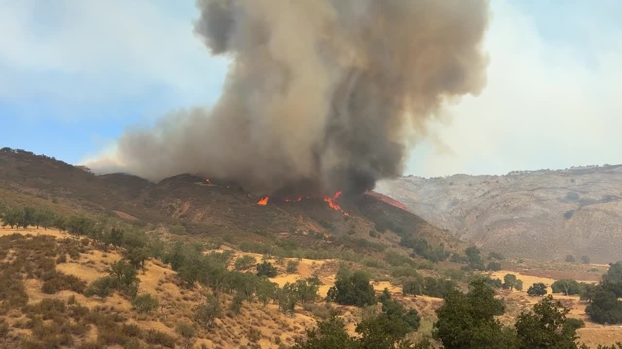
WATCH: Scenes from day 5 of the Gifford Fire
Despite the logistical challenges, there may be one silver lining: history. Burn scars from previous wildfires, including the massive La Brea Fire in 2009, are starting to have an effect on the current blaze.
“We anticipate to see the same slowing when the fire enters the La Brea burn scar,” Bertelsen said. “And not just the rate of spread slowing down. The expectation is also that we’ll see lower intensities in the fire itself. Probably, firefighters will have an opportunity to have more success with their control lines and might be able to engage the fire more directly in places where previously it would be too volatile and too hot to engage.”
But history is also part of the problem. Previous fires and rugged topography mean the landscape is scarred with regrowth and overgrown fuel, some of it from decades past, making it hard to predict exactly how this fire will behave.
Highway 166, which typically provides a reliable control line during fires in this region, has proven ineffective this time.
“Normally, when we get fires off of Highway 166, which is not uncommon, we usually have the benefit of having Highway 166 as a control line that we can actually use to anchor and flank off and attack the fire, because fire will usually choose one side of the road, not both," Bertelsen explained. “This time, we’ve got kind of a multi-front fire, fanning out really in all directions, and we’re starting kind of behind the curve where the Highway 166 itself is just as useless as the control line for us.”
Bertelsen added that while firefighters are working tirelessly to contain the fire, the conditions they’re operating under are unlike most people might imagine.
“It’s deceptively steep country,” he said. “We always say, if you can fight fire here, you can fight fire anywhere... You got to have legs like a goat and superior conditioning to fight fire in this country. There’s also just old-growth brush that’s just brutal to try to make your way through. Very slow production rates for the hotshot crews working through that type of fuel with their chainsaws.”
Weather hasn’t made things worse, but it hasn’t offered much relief either.
“This fire has been occurring in just very typical early August conditions,” said Rich Thompson, an Incident Meteorologist with the National Weather Service. “No abnormal winds, no extreme heat, no rain, no anything. It’s been a very typical early August.”
Despite the lack of extreme weather, Thompson says the geography of the wilderness still makes the fire behavior unpredictable and erratic.
“You might have a south wind in this one canyon,” he explained. “Another canyon might be oriented in different directions. You get a different wind direction and so forth. And so just those local winds just in the canyons and so forth really cause the fire to move along with the topography.”
Humidity levels have also remained low.
“Humidity has been dropping down into the teens and the mid-20s each afternoon,” Thompson said. “Overnight recoveries at night have been moderate at best, maybe 40 to 60 percent. So really, no huge help with humidity.”
Bertelsen says there is one part of the fire showing better containment progress, the north side, where topography starts to flatten toward the Carrizo Plain.
“The northern part of this fire is a little bit more forgiving,” Bertelsen said. “The terrain’s a little more forgiving as the terrain tapers out as you hit the Carrizo Plain, so better progress on that north side for sure.”
Fire officials continue to monitor the shifting conditions closely, but they warn that on the southern edge, the fire still has plenty of room to grow and not many natural barriers to stop it.
