


There is a new version of this story. For the latest updates, click here.
—
UPDATE (8:09 p.m.) – Fire officials say three people have been injured due to the Gifford Fire.
One person described as a civilian was taken to the hospital by helicopter to be treated for burn injuries. Two contractors involved in a UTV rollover were also injured. Officials say one person with moderate injuries was hoist-rescued and taken to the hospital by helicopter. The other person was taken to the hospital by ambulance to be treated for minor injuries.
The fire is burning in steep and rugged terrain just west of the Madre Fire burn area with the majority of the fire activity happening south of Highway 166 in the Los Padres National Forest in Santa Barbara County.
Sixty structures are threatened and evacuation warnings and orders have been issued to 226 people.
—
UPDATE (6:24 p.m.) – A temporary evacuation center for people impacted by the Gifford Fire is now open at Benjamin Foxen Elementary School, 4949 Foxen Canyon Rd., in Santa Maria.
The Red Cross is on site to assist anyone needing help.
—
UPDATE (5:10 p.m.) - The Gifford fire has burned 30,519 acres and is 5% contained as of Saturday afternoon, according to the Los Padres National Forest.
The agency says the fire is burning actively on both sides of Highway 166, with more active spread on the south side.
Highway 166 remains closed between Highway 101 and New Cuyama.
__
UPDATE (1:55 p.m.) - New evacuation orders and warnings have been issued for residents living near the Gifford Fire.
According to CAL FIRE, people in evacuation zones LPF-018, 165, SLC-335, SLC-336, SBC-159A, SBC-161A, SBC163, and SBC167 have been ordered to leave immediately.
Zones LPF-016, LPF-017, LPF-019, and SLC-337 remain under evacuation orders as well.
Evacuation warnings have been issued for zones LPF-015, SLC-297, SBC-159B, SBC-161B, and SBC-169-A.

The County of Santa Barbara Health Department is offering help to people who have pets and are impacted by the Gifford Fire.
Officials say residents can call Santa Barbara County Animal Services at (805) 681-4332 for help with livestock and large animals.
Community members can also bring domestic pets to the Santa Ynez Valley Humane Society at 111 Commerce Drive in Buellton.
__
UPDATE (11:10 a.m.) - CAL FIRE reports that the Gifford Fire has burned 23,588 acres in South San Luis Obispo and North Santa Barbara Counties.
The blaze is still 5% contained.
Los Padres National Forest officials say the fire is burning on both sides of Highway 166 in thick brush and rugged terrain.
__
UPDATE (9:40 a.m.) - The Gifford Fire has prompted an air quality alert for the Cuyama area and an air quality watch for all other parts of Santa Barbara County.
A Los Padres National Forest Public Information Officer told KSBY on Saturday morning that the fire was burning in a southerly direction.
—
UPDATE (6:47 a.m.) - The Gifford Fire had burned 12,400 acres by Saturday morning and was 5 percent contained, according to CAL FIRE.
Evacuation orders for four zones shown in red on the map below remain in effect.
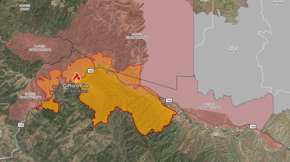
The fire is burning just west of where the Madre Fire broke out one month ago. A Los Padres National Forest Service spokesperson says the burn scars from the Madre Fire are helping box in the Gifford Fire.
—
UPDATE (6:50 p.m.) - The Gifford Fire has burned an estimated 5,000 acres, according to CAL FIRE.
The fire is burning mostly within the Los Padres National Forest.
___
UPDATE (5:57 p.m.) - In San Luis Obispo County, evacuations have been ordered for the following zones: LPF-016, LPF-017, LPF-019, and SLC-337.
This includes the area north of Highway 166, east of Cable Corral Road, south of Tajea Flats Road, and west of Chimineas Road.
Click here to determine your evacuation zone.
___
UPDATE (5:30 p.m.) - Evacuations have been ordered in Santa Barbara County for the area south of Highway 166, east of Willow Springs Trailhead, and west of Cottonwood Canyon Road.
WATCH: Video from the scene of the Gifford Fire
___
UPDATE (3:52 p.m.) - The Gifford Fire, made up of a series of fires that broke out Friday afternoon on Highway 166 east of Santa Maria, has so far burned 818 acres, according to CAL FIRE.
Containment is 0%.
___
UPDATE (3:04 p.m.) - Highway 166 is closed between Highway 101 and New Cuyama as a result of the fire. There is no estimated time for reopening.

___
(2:41 p.m.) - Firefighters are responding to a series of brush fires along Highway 166 near the Gifford Trailhead, about 30 miles east of Santa Maria.
According to Los Padres National Forest officials, there are four separate fires along the north side of the highway, ranging in size between two and 10 acres.
The fires were first reported at about 1:55 p.m.
According to the California Highway Patrol, a portion of 166 is expected to be closed due to the fire.
The Gifford Fire is burning just west of where the Madre Fire broke out one month ago. That fire burned a total of 80,779 acres before reaching 100% containment in late July.
This is a developing story and will be updated with new information as it becomes available.
