


———9:45AM Update———
——— Update 8:00 AM———
Several scattered storms have brought snow to peaks around the region and snowy/icy conditions to the Cuesta Grade.
Authorities are urging extreme caution on the roadways this morning.
Check out this story for many of the photos collected of this morning's snow.
——— Original Article———
Good Morning Central Coast! There is a lot going on in the forecast right now so lets jump right in.
There are a lot of moving parts in this forecast as two large systems interact to the north of us while instability from a departing system continues Thursday. This combination will be bringing strong winds, heavy rain and significant snow into the weekend. Tale caution conditions will get dangerous fast.
First lets talk timing...
Scattered showers will continue through most of the daytime hours today ahead of the "main event" that will bring significantly more rain and snow to the Central Coast and make for a very messy Friday.

The leading edge of the rain will move in this evening, bringing with it heavy rain that will increase into the overnight hours. Heavy rain, thunderstorms and snow is expected overnight.
By Friday Morning's commute things will be tricky with a lot of rain and snow above ~1200ft.


Through all of the daytime hours heavy rain is expected with more snow accumulations into Friday evening.

Saturday morning the storm will break but scattered showers will remain into the afternoon.

This all boils down to that Friday is going to be messy from start to finish. I urge everyone to pay attention to the watches warnings and advisories in place and be prepared for power outages and extreme weather.
The big talking point of the storm is the snow that it is producing. This strong winter storm is very rare and is bringing snow to the region thanks to falling snow levels.
Wednesday the snow levels fell to around 1000ft in elevation. This dusted many peaks with a little "appetizer" of what is to come. Today snow levels are slightly higher but are still low enough that many interior valley floors will see snowfall and peaks will certainly receive impactful accumulations.
The bulk of the snow is expected to fall from Thursday night through Sunday Morning. More detail on the storm timing, rain, wind and other hazards is discussed further down this article.
At valley floors and most locations from 1200 to 2000 ft a few inches of snow (1-4") is expected. This will cause some concerns for communities including Paso Robles, Santa Margarita, Shandon, California Valley, Cuyama, Cachuma and most of the peaks surrounding those communities.
As you go up in elevation the expected snow accumulations will rise significantly. From 2,500-4,000 in elevation (Most of the peaks in Santa Barbara county's interiors) we could see 1-3 feet of snow. This will cause significant concerns for roads in this already tricky to navigate area.
Areas above 4000ft will see the most snow of all. More than 3 feet of snow is expected at the highest peaks in Santa Barbara county (Think Figueroa Mountain, Big Pine Mountain, and Devils Peak.) Outside of our direct region portions of the Grapevine are expecting up to 7 ft of snow. This will likely close the pass and divert significant traffic to Hwy 101 through the Central Coast. Added long range transport traffic is expected until the storm clears.
It isn't hard to see that this storm has absolutely massive snow potential. Here is a look at one of the models that I think we will be close to for snow accumulations over the next couple of days.

Not only are accumulating snows expected, but the winds will also be blowing so we have winter weather advisories, winter storm warnings, and even the first blizzard warning since 2006 issued by the National Weather Service for the Santa Barbara County mountains. Here is a rundown of the winter weather alerts.
Blizzard Warning
In effect from 4AM Friday to 4 PM Saturday for the interior valleys and highest elevations of Santa Barbara County. Expect heavy snow, wind gusts up to 65 mph and near zero visibility. Total snow accumulations from up to 6 inches of snow down to 2000 feet to 1 to 3 feet above 3500 feet. Isolated snow amounts to 5 feet on favored peaks.

Winter Storm Warning
In effect from now through 4AM Friday (when the blizzard warning becomes active) for the interior valleys and highest elevations of Santa Barbara County. interior high elevation valleys in San Luis Obispo County including the edges of Cuyama valley and the Carrizo Plain. Expect snow, wind gusts up to 50 mph and low visibility. Total snow accumulations from 1-3" more possible on favored peaks.

Winter Weather Advisory
In effect from now through 4AM Friday (when the blizzard warning becomes active, I believe that this will be extended into Saturday.) For the interior valleys and elevations over 1000ft of both San Luis Obispo and Santa Barbara Counties. Expect snow on the valley floors 1-3" and at foothils and favored peaks up to 6 inches of snow. Gusts up to 45mph are expected.
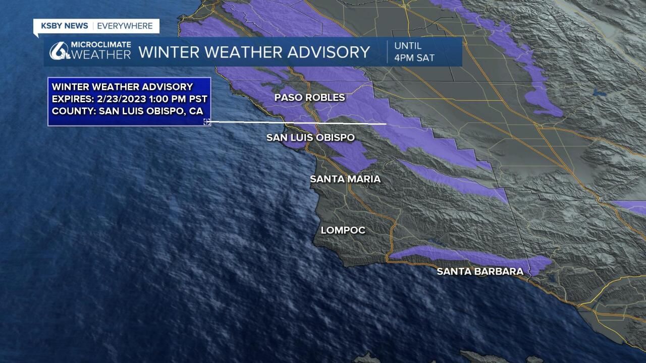
When you put that whole picture together there are winter weather alerts in place for all locations above about 1000 ft of elevation from now through 4PM on Saturday.

Now, this may seem like the headline, but I think the larger concern is the potentially high rainfall and rain rates possible Friday into Saturday. For up to date rain totals for the region check out this link.
While snow will be falling at the highest elevations, where temps are not quite cold enough we will see significant rain. We are just on the northern edge of the main storm system so there will vbe less accumulations in Northern SLO county as compared to the South Coast. Most models like 1-3" inches of rain is possible through Sunday for all but those high elevations and the south coast of Santa Barbara County.
Along the coast the totals bump up to 2-5" with more possible at some favored points at higher elevations. This rain will fall from Thursday niht all the way through Saturday morning. Local heavy rain rates are possible up to 1" per hour. At those rates there is risk for small stream and localized flooding as well as debris flow potential around recent burn scars. When all added together there will be very significant rain and snow chances across the region and specifically in the Sierra Madre and San Rafael mountain ranges.
This risk has prompted a flood advisory for the Santa Barbara County South Coast as well as the Interiors of Santa Barbara County. The advisory will stay in effect through 6 PM Saturday.

An additional concern that I must add is that many of the drainage systems in our region are still dealing with added sediment and damage from the storms in early January. In some spots this may cause additional flooding.
There is thunderstorm potential today, Friday and into early Saturday morning. This has placed all of coastal California with risk of thunderstorms today and tomorrow according to the Storm Prediction Center.
The Weather Prediction Center has the South Coast area in its excessive rainfall outlook for Friday into Saturday.

Surf is also quite high and surf advisories continue.

I can't say this strongly enough: please heed advisories and warnings. Please click on the associated material to fully examine the graphics which contain forecast details about all the advisories. Also, these advisories will change as time progresses so please have a weather app like the KSBY Microclimate Weather app to follow the latest watches, warnings, and advisories.
Believe it or not, more active weather is likely next week and the first week of March.
Have a great day Central Coast!
