

Wow, it was a scorcher Thursday across the Central Coast with high temps soaring to record highs for a few spots. Here is a look at the daytime high temps for Thursday.

That temp of 95° may not be the hottest temp on the map, but it is still very significant. That marks a new record high for August 21st. The previous record was 92° set back in 1997.

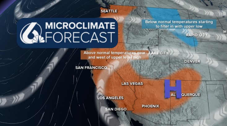
The high-pressure system sitting over us has stayed put and will continue to bring high temps, low humidity, and high winds to the region.

Friday will kick off clear once again as the marine layer stays banished offshore. That will kick off a warm day where highs will soar to 10-15 degrees warmer than normal for this time of the year.

Into the end of the week, highs will stay uncomfortably hot. The combination of limited marine influence, gusty offshore winds, and uninterrupted sunshine will skyrocket the temps. The heat peaks on Friday and will take a few days to ramp down. Here is a look at the 7-day forecast.


Those high temperatures have prompted an Extreme Heat Warning for the interiors of San Luis Obispo and Santa Barbara counties through Saturday evening. That is an upgrade from the watch that was in place on Monday. Temps upwards of 105° are expected for that area. Additionally, a high heat advisory has been issued for the coastal valleys through Friday night. Temps upwards of 90° are expected in this region.

Be sure to stay hydrated, limit exposure to heat during the warmest hours, and check in on vulnerable people in our communities.
The heat will combine with low humidity and the aforementioned winds to increase fire weather concerns. There is a Fire Weather Watch in place for the interiors of Santa Barbara County and the southern interiors of San Luis Obispo County through Sunday night. This does include the Gifford Fire burn zone. I will keep a close eye on this concern.

Late next week, the temps will start to cool as the pattern is broken up. The good news is cooler temps, the bad news is thunderstorm chances bring risk of dry lightning to the region Friday through Sunday. This thunderstorm risk isn't close enough for much detail, but we will stay on the far NW side of the storms. I'll bring you updates as they become available.

Stay weather aware!
-Vivian
