

Wednesday brought us hot weather and more rapid fire growth for the Central Coast. Before I dive into the forecast, here are a few links to have on hand.
The Gifford Fire CalFire Incident Page
Air Quality Information San Luis Obispo County
Air Quality Information Santa Barbara County
Let's start with the reason all of those links are important... the Gifford Fire.
Winds, high heat, and very low humidity have combined to create more fire weather danger and another day of erratic fire weather behavior. Wednesday night, just after 5 p.m., new acreage information was released. As of that update, 91,278 acres have burned, and containment sits at 9%. With that update, more evacuation zones have been announced. Here is the latest information on evacuation orders.

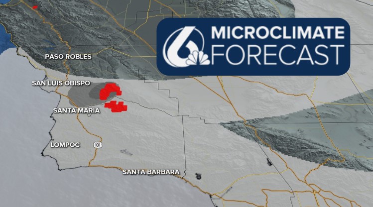
I used the satellite information on the fire to compile this map, color-coded with the brightest colors indicating most recently burned areas.

Winds have been pushing significant smoke West through the day Wednesday. That has made a big impact in visible smoke and air quality concerns. You can see in this map all the mid-level smoke pushing west, towards Santa Maria and the 5 cities.

Air quality will continue to be a concern over the next few days as the fire blazes.
Turning to winds, today gusts up to 35 mph aided in erratic fire weather behavior. Overnight winds will calm slightly but are expected to strengthen once again into the afternoon on Thursday.
The weather pattern that has brought us this heat, as well as the dry and windy conditions, is going to continue. The driving high pressure is to our South East and is bringing temps over 110° for portions of the South West.

As far as our temperatures are concerned, highs will stay above normal for this time of the year through much of the forecast. Here are Thursday's highs.

Into the weekend, the pattern will shift slightly. Another high pressure will start moving in from the North Pacific, and while that transition takes shape, highs will fall a few degrees (not much, but at least something). Early next week, that high pressure will arrive and bring back triple digits for the interiors and highs in the 70s and low 80s for our beaches.


Be sure to stay informed with the rapidly evolving conditions concerning the Gifford fire.
-Meteorologist Vivian Rennie
