

The first of several storms has arrived and will bring us concern through the night.
Before I dive in, here are a few links that I find helpful to have on hand through a storm.
I will be updating this article throughout the night with any new information.
——— Midnight Update from Meteorologist Vivian Rennie ———
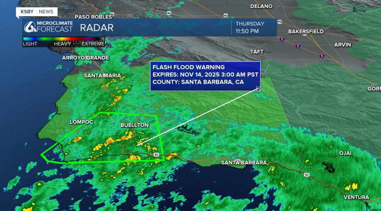
A Flash Flood Warning has been issued for southwestern Santa Barbara County from 11:49 p.m. through 3 a.m.
Flash flooding is expected in creeks, streams, urban areas, and on roads/highways.
Between 1.5 and 3.8 inches have fallen in this area already, and as the heavy rain continues, flash floods are likely.
Some communities included are Buellton, Solvang, Jalama Beach, Point Conception, Gaviota State Park, Refugio State Beach, and Highway 1 between Highway 101 and Lompoc.
——— 8:30 p.m. Update———
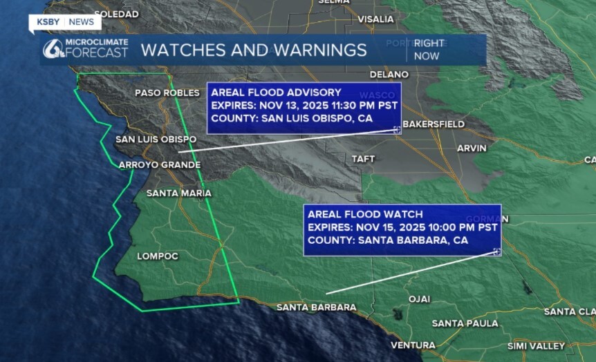
Thanks to the rain falling across our coastal valleys and western beaches, an Areal Flood Advisory has been issued for the area in the light green polygon. This will stay in effect through 11:30 p.m.
Minor flooding in low-lying and poor drainage areas is ongoing, and there is water on many roadways.
——— 4:30 p.m. Update———
Here is a storm discussion from Meteorologst Vivian Rennie.
———Original Article———
The rain began along the north coast of SLO County early this afternoon. As of 3 p.m., the core low pressure is sitting just offshore.
Over the next few hours, the cold front will push onshore and bring a band of heavy rain and strong winds. Within this front there is also the chance for an isolated thunderstorm or two.

Overnight, the rain will spread out and bring more mild, yet consistent for all of the region.

By early Friday morning, this first storm will have passed, and we will have a short (and imperfect) break in the rain. Sunday, more will return. Details on the next few storms are a bit further down in this article.
This first storm will bring us pretty good rain totals, around an inch and a half for many coastal valleys and beaches, closer to two inches at the highest peaks. Interior valleys will be closer to a half inch.

Winds while the front passes will get upwards of 45 mph. This has prompted a high wind advisory for most of SLO County and Western Santa Barbara County through 6 p.m. Thursday.

There is also a high surf advisory in place for the western beaches through 9 a.m. Saturday.

The National Weather Service has also issued a Flood Watch for much of Santa Barbara County through 10 p.m. Saturday.

The Office of Emergency Services is warning of potential flooding at the Gifford/Madre fire burn scar. Officials say the burned soil is less absorbent, making it more prone to repelling the water and causing a flash flood.
Now let's dive into the storms headed to us over the weekend. These are a series of cutoff lows that will track over the region. Unfortunately, there is a lot more uncertainty with these storms. Timing and accumulations are a bit tricky. This is my forecast as of Thursday afternoon.
Very early Saturday morning, the first cut-off low will retrograde into the region, bringing widespread rain.

That rain will continue through the afternoon, with some heavy bands for the south coast of Santa Barbara County.

Some heavy accumulations are expected for the peaks; this is why the flooding watch lingers into Saturday night.
Sunday will be another imperfect break with a few small showers moving through, but thankfully nothing much for the morning hours when the City to the Sea Half Marathon will take place.

The break will be short-lived, another cold front will reach us Sunday night into Monday morning.

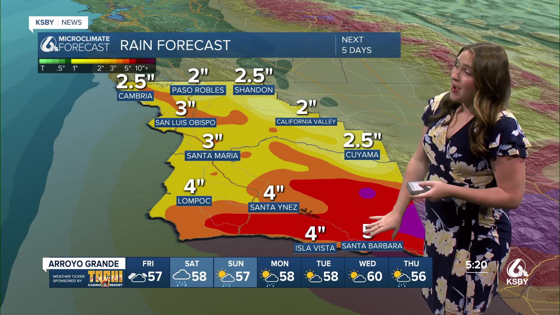
All said and done with all those storms combined will bring the potential for a LOT of rain. Here is a look at the total rain over the next five days.

Thankfully, that is a long time for all the rain to fall; thankfully, most of it will absorb into the soil and not cause too many issues. I am still watching localized flooding, though.
Throwing in the typical forecast elements now. Here are Fridays temps!

Here is your weekend forecast.

And here are the 7-day forecasts.


Stay weather aware through the evening and over the next few days as the storms progress.
-Vivian
