

Friday brought more heat, low humidity, and strong winds to firefighting efforts across the region. There is a little good news in the forecast, though, calmer winds are on the way into the weekend before another warm up.
Before I dive into all of that, here are a few links to keep on hand.
The Gifford Fire CalFire Incident Page
Air Quality Information San Luis Obispo County
Air Quality Information Santa Barbara County
The Gifford fire began burning exactly one week ago in San Luis Obispo and Santa Barbara counties. There are now over 3,000 personnel responding to the scene, including over 200 engines and over 80 water tenders.
Here is a current map of the Gifford fire as of 4:53 p.m. At that hour it stood at 104,590 acres and 15% containment.

For more of our coverage on the Gifford fire, click here.
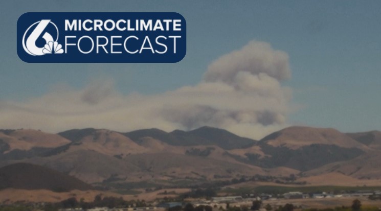
As the fire has continued to burn much of the region has been able to see plumes of smoke and cloud cover emanating from the flames. I want to take a moment to explain what is going on there, meteorologically.
What we are actually seeing is pyrocumulus clouds, extending thousands of feet into the air. These clouds are formed by air heated at the surface by the combination of solar rays and the actual fire rising quickly. These super heated parcels of air become positively buoyant (they rise) and cool down in that process.

Once they cool down enough, the small amount of moisture in that air condenses onto the smoke particles, forming a cloud. Because they are still so much warmer than the air surrounding them, those parcels continue to rise quickly eventually reaching the heights that we see them at. They only stop rising when they become cooler and drier than the surrounding air.

These fire-based clouds are not only interesting to watch but can cause significant concern for firefighting efforts. Hot surface-level air rushes into the fire to replace the rapidly rising air. This increases airflow and wind gust speeds in already tricky fire spots. Additionally, once the hot air stops rising, it will fall back to the surface, potentially creating strong winds around downbursts many miles away.
Now let's dive into the forecast for our fires as well as the weekend ahead!
Friday's high temps were a touch lower than previous days, with highs in the mid-90s for interior valleys (that is a couple of degrees drop) 70s for most coastal valleys, and 60s at the beaches. San Luis Obispo stayed a little warmer with highs reaching the low 80s today.
That slightly cooler pattern is also joined by calmer winds. Today, gusts hovered around 20 mph with localized winds up to 30 mph right by the Gifford fire. That is a slight decrease when compared with previous days. Calmer winds will help limit erratic fire weather behavior.

Into the evening, winds will calm even more, with gusts overnight staying below 10 mph. That is very good news for firefighting efforts overnight. Saturday onshore winds will pick up again, once again nearing the 20 mph threshold.
If you are headed to the Concerts in the Plaza in Downtown San Luis Obispo tonight, it is going to be very comfortable. Moving from the low 70s to the upper 50s as the sun goes down, with minimal winds and some marine fog rolling in later this evening.

Saturday morning will start with marine layer clouds and fog for western beaches and coastal valleys. By mid-morning, that cloud cover will burn off from the valleys and allow for more sunshine. I expect another dense fog advisory to be issued for our beaches and coastal valleys.
Temperatures will rise once again tomorrow into the mid-90s in interiors, 70s for coastal valleys, and 60s by the beaches. That is right around normal for this time of the year.

Sunday, a high-pressure system will settle into the region and once again bring hot temps to the region. That means that triple digits will return once again for the interiors next week. That will be a short-lived warm-up up though, temps will fall once again into the latter half of the week.


Temps for coastal valleys and beaches will see much less change from the next high-pressure system. Upper 70s for Santa Barbara, mid 70s in Santa Maria, and low 80s for San Luis Obispo.
Be sure to stay informed and stay safe, Central Coast!
-Vivian
