Tuesday will be somewhat of a transitional day ahead of the rain that is in the forecast for Wednesday and Thursday. It will start out with dense fog throughout the morning commute and then turn into mostly cloudy skies by the afternoon.
Daytime highs will range from the low to upper 60s for most of the area and winds will remain mild and within 10-20 miles per hour.
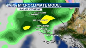
Models are in agreement that the Central Coast will see some rain Wednesday morning that will bring scattered showers throughout the afternoon. The system will continue Wednesday night throughout most of Thursday.
This system has the opportunity to bring some measurable rain to the area. On the low end it could produce 0.50” to 1” of rain, and on the more generous end, it could bring more than 2” of rain.
As the system moves south, debris flow and rockslides are a possibility near the burns scars for the Woolsey and Hill fires.
As the storm approaches the area, a high surf advisory for the Central Coast will remain in place from Tuesday afternoon through Friday. The surf could range from 10-18 feet with sets up to 20 ft.

