

Happy Tuesday evening, Central Coast!
We have been talking about a big pattern shift for over a week, and now the storm has arrived. In large-scale storms, I find it helpful to have a few links on hand:
- Radar
- PG&E Outage Map
- SoCal Edison Outage Map
- Interactive Rain Totals Map
- CHP Incident Information Page
In storms like this, it is best to have multiple ways to receive storm updates. I recommend our KSBY Microclimate Weather App. It will automatically send a notification if severe weather alerts are in place.
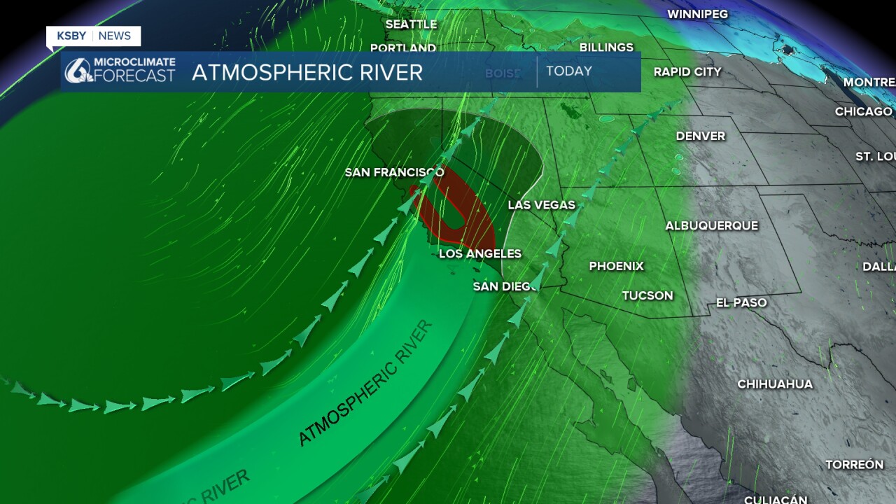
Let's dive into the details! The strong atmospheric river that we have been tracking has started to rotate, which will bring the core of the moisture right in line with the coast, bringing us significant rain and strong winds.
The rain will begin today with some light showers on the leading edge of the storm. Those showers won't amount to much, but they will be accompanied by the start of strong winds. South/southeast winds 30-50 mph with damaging wind gusts up to 70 mph are expected. The high wind warning is in place from noon Tuesday until 3 p.m. Friday.

Within the first band of showers, we can expect fast-accumulating rainfall, especially along the east-west ridges and south coast peaks.
Some spots could pick up over an inch of rain in just a few hours, which creates concern for flooding as well as mud and debris flows for areas impacted by fires, as well as spots with loose, slide-prone soils.

That danger has put us in the high risk (5/5 on the scale) for excessive and problematic rainfall for the South Coast.

Additionally, there is enough rotation (vorticity) in our atmosphere with these storms to create the risk for severe weather. Tonight, Christmas Eve, and Christmas Day will all have a small chance for weak tornadoes as well as water/land spouts. That risk is small but not out of the question.

Because of the massive rain totals expected, there is a flood watch in place through 10 p.m. Wednesday for the whole region.

Additionally, this storm is riling up our seas. There is a surf advisory in place for all of our beaches through 11 a.m. Saturday. Large breaking waves 10-15 ft and dangerous rip current risk are expected.

By Wednesday morning, the initial front will have passed, but the storm is still far from over. The storm on Wednesday, Thursday, and Friday will all be messy with significant rain and more winds, severe weather threats, and potential flooding.
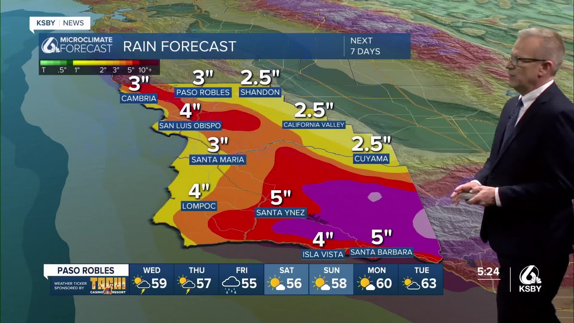
All said and done, we are expecting heavy rain, 3"-5" for most spots, but the peaks of Santa Barbara County can expect closer to 9 inches of rain.
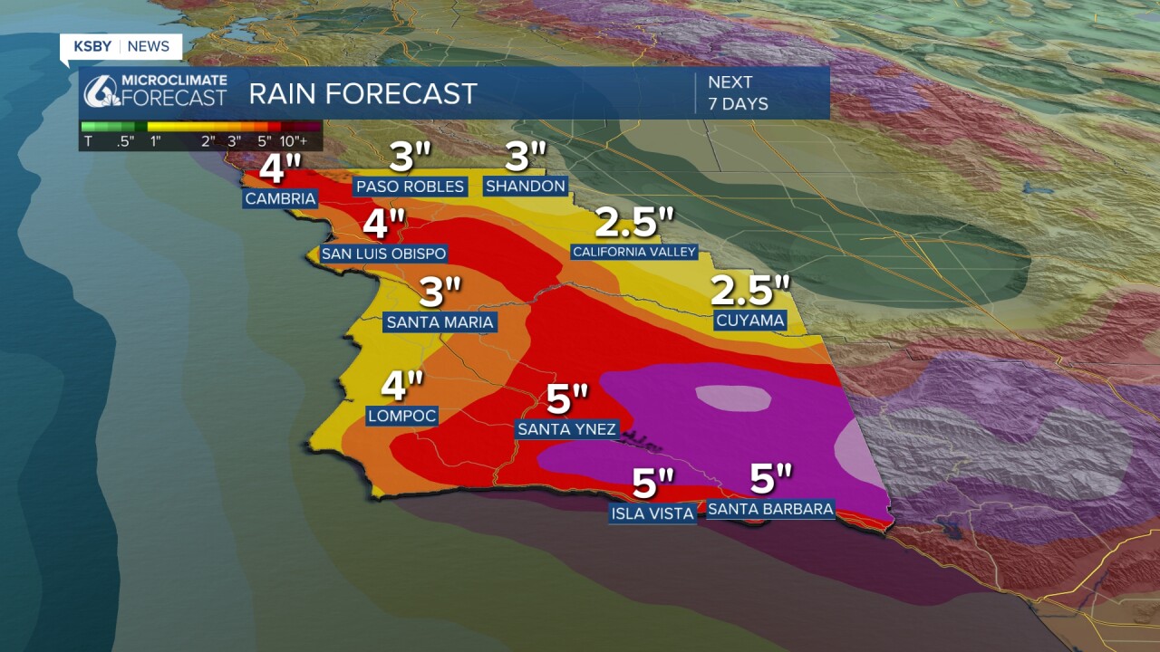
Here is what all of that looks like on your 7-day forecast!


Stay weather aware tonight and through the week as the storm progresses.
