


Good Monday evening, Central Coast!
Rain and thunderstorm chances for Friday and Saturday, with a lingering rain on Sunday. There will be dry time in between the rain and thunderstorm chances.
Rain and thunderstorm chances begin later on Friday and continue into Sunday.

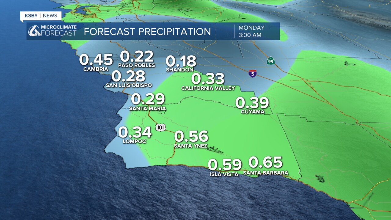
Below: The potential rainfall amounts from Friday through Sunday. If your area has a thunderstorm, rainfall amounts could be over 1.00" and up to 2.00".

Cooling Trend Brings Relief to the Central Coast
Weather lovers along California's Central Coast are in for a treat as a significant cooling trend takes hold across Santa Barbara and San Luis Obispo counties. After recent warm conditions, temperatures are dropping and will continue to cool through Tuesday as increased onshore flow brings marine layer clouds and fog back to coastal areas.
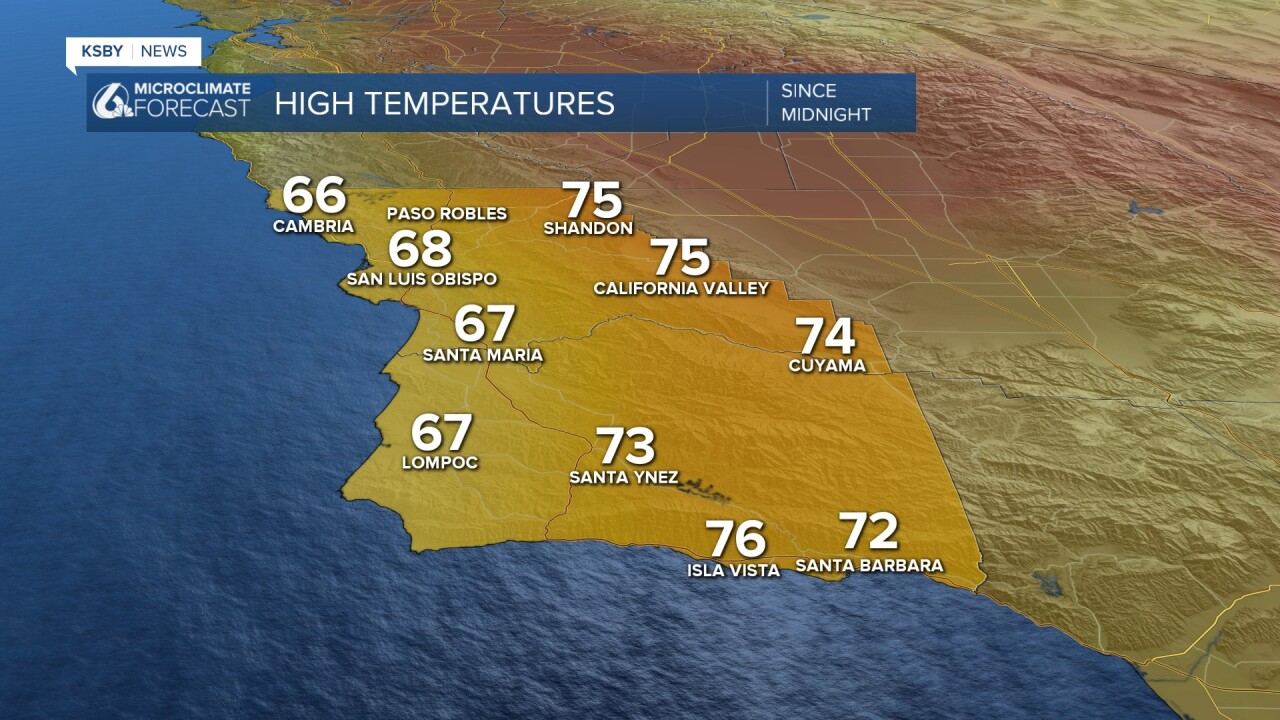
Below were the high temperatures on Monday, April 6th, 2026.
Through Thursday: Another Cool Down Begins
Immediate Changes:
- Coastal and valley areas will see temperatures drop 3-6 degrees from yesterday's highs
- Beach communities could experience drops of up to 10 degrees
- Low clouds and fog will increase near the coast as the marine layer strengthens
Wind Patterns by County:
Santa Barbara County - A wind advisory is in effect for the western Santa Ynez Mountains and southwest Santa Barbara coast, with gusts reaching 35-50 mph. The strongest sundowner winds will occur tonight from Gaviota to San Marcos Pass. These notorious downslope winds are expected to shift eastward into the eastern Santa Ynez range by Tuesday night.
Weekend Cold Upper-Level Low Pressure Storm System Approaches
Friday Through Sunday: Rain chances return
The weather story takes an exciting turn as a cold upper-level low-pressure system moves into the region:
- Thursday Night: Light rain becomes possible, especially north of Point Conception
- Friday-Saturday: The main event arrives with cooler temperatures, rain, and thunderstorm chances
- Rain Totals: Generally 0.25 to 1.0 inch, with locally higher amounts up to 2 inches possible in mountain areas and any local area that has a thunderstorm
- Sunday: Rain is looking more likely.
This storm system's cold and unstable nature makes it particularly interesting for weather enthusiasts, as it could produce dramatic thunderstorms - a relatively rare treat for the Central Coast.
What Makes This Weather Pattern Special
For weather lovers, this forecast offers a perfect example of California's diverse microclimates in action. The contrast between Santa Barbara County's famous sundowner winds and San Luis Obispo County's Santa Lucia wind patterns showcases how topography creates distinct weather personalities just miles apart.
The upcoming storm system represents a classic late-season Pacific storm - cold, unstable, and capable of producing the kind of dramatic weather that makes the Central Coast such a fascinating place for weather watching.
Stay tuned as this dynamic weather pattern unfolds across your beautiful Central Coast counties!


Have a great night, Central Coast!
-Jim
