



Hello, Central Coast!
Here is your weather forecast for San Luis Obispo and Santa Barbara Counties
Current Conditions
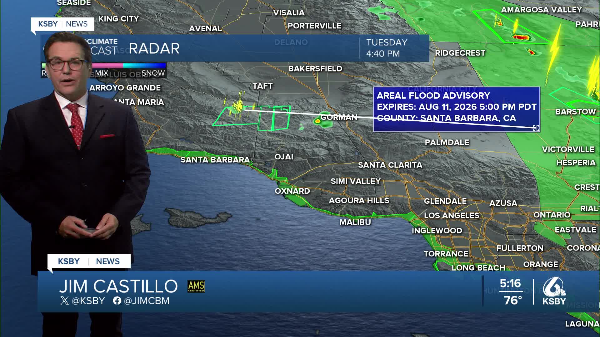
A few thunderstorms are centered over northeastern Santa Barbara County, producing numerous lightning strikes and heavy rainfall. A Flood Advisory has been issued in that area until 5 pm. AFlash Flood Warning for extreme northern Ventura County ended at 4:15 pm. Isolated showers extend from Los Angeles through western Ventura County. The thunderstorm risk will persist into early evening hours, making this an important day to check conditions before visiting weather-exposed areas like beaches or mountains. Additional storms may roll off of the mountains into the Cuyama Valley.
Cooling Trend Continues
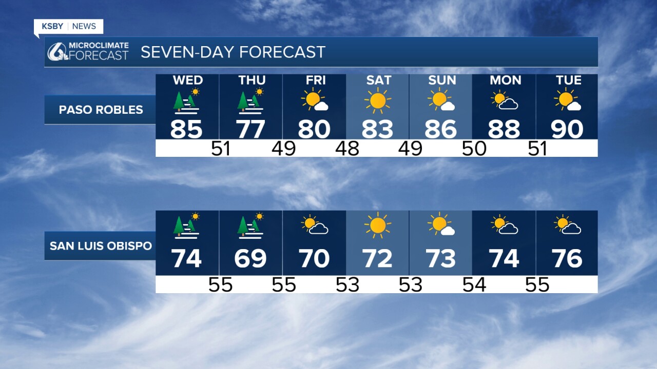
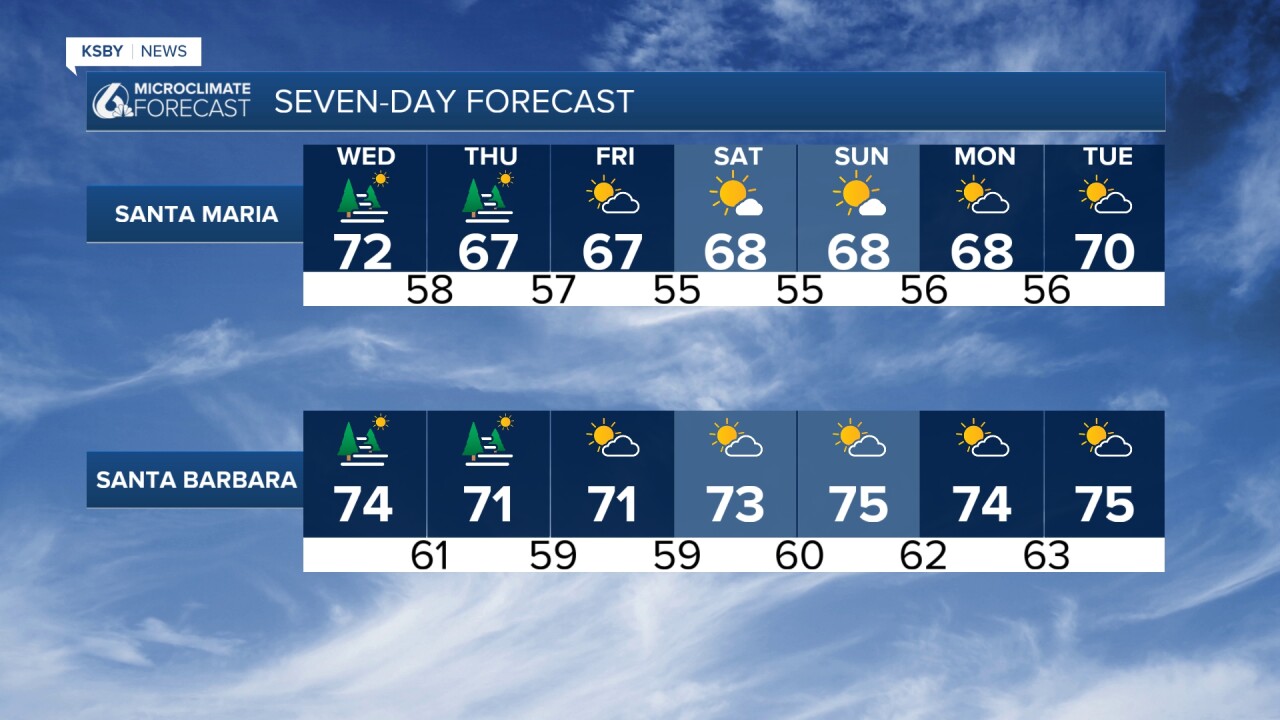
A significant cooling trend will persist through Thursday, with temperatures dropping well below normal across both counties. The strong high-pressure system currently positioned over the Four Corners region is shifting eastward, allowing a trough to move down the California coast and finally bring relief from the inland heat.
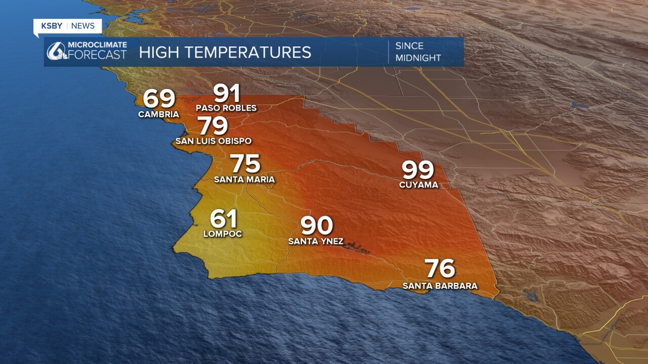
Below: The high temperatures for the area on Tuesday. The 91 degrees was a few degrees below average in Paso Robles, and the high in San Luis Obispo was right on the average of 79. Santa Maria and Santa Barbara were average in the mid 70s.
Tonight Through Wednesday
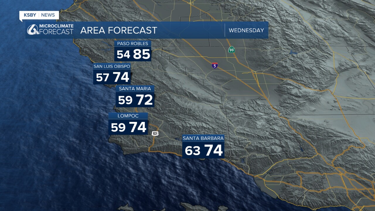
Moderate onshore flow will bring continued cooling to the region. Mountain and valley locations will see temperatures drop below normal levels. Tonight should feature fewer high clouds, and the moderate onshore flow will allow low clouds to form and spread across most coastal areas.
Wednesday brings a trough over the West Coast. The combination of onshore flow, marine layer development, and lower atmospheric heights will drop maximum temperatures a few more degrees. This cooling will bring below-normal temperatures to nearly the entire forecast area.
Thunderstorm Activity: The upper-level trough along the coast could introduce additional moisture. Combined with elevated instability, this creates a 10-15% chance of afternoon thunderstorms across much of San Luis Obispo and Santa Barbara Counties on Wednesday.
Thursday Outlook
Strong onshore flow continues into Thursday. The upper-level troughing and strong surface onshore flow will likely produce a robust marine cloud layer extending well into the valleys. Clearing will be slow, with some beaches remaining cloudy throughout the day. Maximum temperatures will drop a few more degrees, and it's unlikely any station will reach 90 degrees.
Weekend and Beyond
By late Friday, the high-pressure system begins its return to the area, marking the slow return of increasing temperatures. The weather pattern becomes less impactful over the weekend.
Saturday through Monday: Expect plenty of nighttime through morning low clouds and fog across coastal areas. The valleys will see decreasing stratus and marine influence as the northward push weakens and atmospheric heights increase, compressing the marine layer to under 1000 feet.
Temperature warming begins Saturday into Sunday, with valleys experiencing the greatest warming as marine influence diminishes. Sunday's maximum temperatures will remain below normal.
Mountain Areas
The Santa Lucia Mountains, Santa Ynez Mountains, and Los Padres National Forest areas within San Luis Obispo and Santa Barbara Counties will experience the cooling trend with potential for convective activity through Wednesday night. Mountain areas should see the most significant temperature drops during this period.
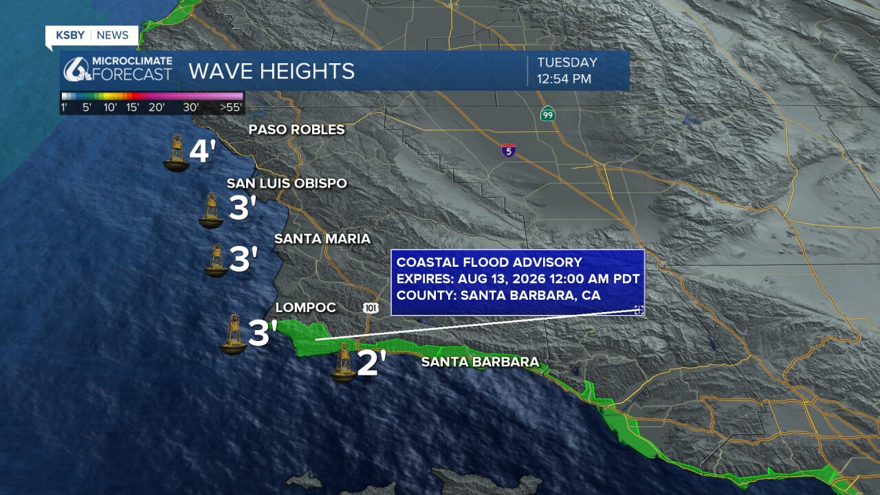
Below: A Coastal Flood Advisory continues until midnight along the Santa Barbara County coast for some minor coastal flooding, especially at high tide between 8 and 10 pm up to 7.5 feet.
Have a nice night, Central Coast!
-Jim
