


Good Thursday evening, Central Coast!
Friday through the weekend, showers and possible thunderstorms, the biggest wave looks to be Saturday night.

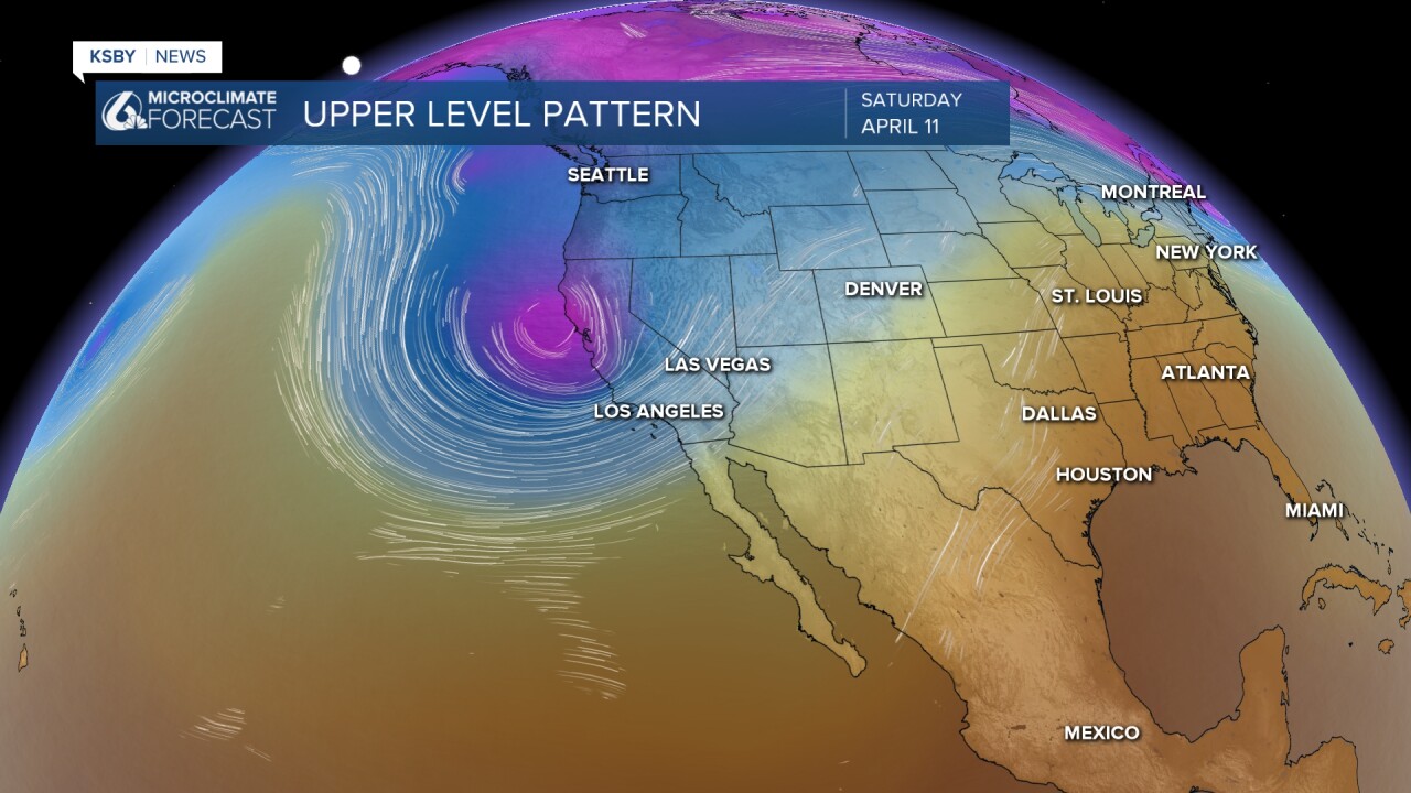
The 2nd area of low pressure arrives Saturday night into Sunday. Below, you can see the cold air aloft represented by the purple color. This cold air aloft will keep things unsettled and chilly.

We are tracking a significant shift in our weather pattern as a pair of Pacific systems set their sights on the Central Coast. For residents in San Luis Obispo and Santa Barbara Counties, expect a definitive end to the recent warmth as a cooling trend takes hold, followed by active weather through the weekend.
Short Term: Cooling Down and Initial Showers
An upper-level low-pressure system is currently approaching Northern California. Locally, this means a return of onshore flow, bringing an increase in morning low clouds, fog, and noticeably cooler temperatures.
Friday into Saturday Morning:
A weak cold front will move across the Central Coast tomorrow.
• San Luis Obispo County: This area will be closest to the atmospheric dynamics. Expect the bulk of the initial activity with a slight chance of thunderstorms and increasing chances of seeing pop-up showers. Rainfall totals are forecast to be only around 0.10 inches with this first system, though the northwest corner of the county could see up to 0.50 inches.
• Santa Barbara County: The front will be weaker here on Friday. Locations north of Point Conception should see light rain around 0.10 inches. The South Coast can expect anywhere from a trace to a tenth of an inch.
• Temperature Impact: Daytime highs will be mainly in the mid 60s.

The Main Event: Saturday night into Sunday with downpours and a chance to hear some thunder along with gusty winds.
A second, much colder and more vigorous 535 dam upper-level low will dive south Saturday night into Sunday. This system carries much more energy and moisture.
Saturday Night and Sunday Morning:
Rain chances jump to over 80% for both counties. This will be a dynamic event characterized by:
• Heavy Rain & some Thunderstorms possible: A strong front will sweep through overnight Saturday. We are monitoring the potential for a few stronger cells, especially north of Point Conception. With cold air aloft, any thunderstorms may bring small hail.
• Rainfall Estimates: Coastal and valley areas are currently projected to receive 0.50 to 0.75 inches. However, the foothills and coastal slopes—including the Santa Lucia and Santa Ynez Mountains—could see 1.00 inch or more due to enhanced southerly flow.
• Winds: Advisory-level southerly winds are possible across the Central Coast and throughout the Los Padres National Forest.

• Snow Levels in the Los Padres National Forest: Cold air will drive snow levels down to approximately 5,500 feet, with accumulations expected above 6,000 feet in our local ranges. If you are traveling through the Grapevine on I-5, we do not expect any travel concerns.
Extended Outlook: Drying Out and Warming Up
The main frontal band is expected to exit Santa Barbara County by mid-morning Sunday, leaving behind lingering showers and a distinct "January-like" chill.
• Monday: While a few nuisance showers may persist early, dry northwest flow will take over by mid-morning. Skies will clear, but temperatures will remain in the 60s.
• Tuesday and Wednesday: High pressure builds back in. Under the strong April sun, we will see a rapid recovery. Highs will return to the 70s for most coastal and valley locations.
We will continue to monitor the speed and trajectory of the Sunday low, as any shifts will impact our final rainfall totals. Stay tuned for further updates.

Below are the levels for our local Reservoirs and the change from last week.

A Winter Storm Warning is in effect above 7,000' for the Sierra-Nevada Mountains Friday through Sunday. 10 to 24" of snow is likely.


Have a great night, Central Coast!
-Jim
