

Happy Wednesday, Central Coast! We have made it halfway through the week and to the end of the "clear" section of our forecast!
Starting tonight and into tomorrow morning, a large-scale system will arrive and bring heavy rain, winds, and the potential for thunderstorms.
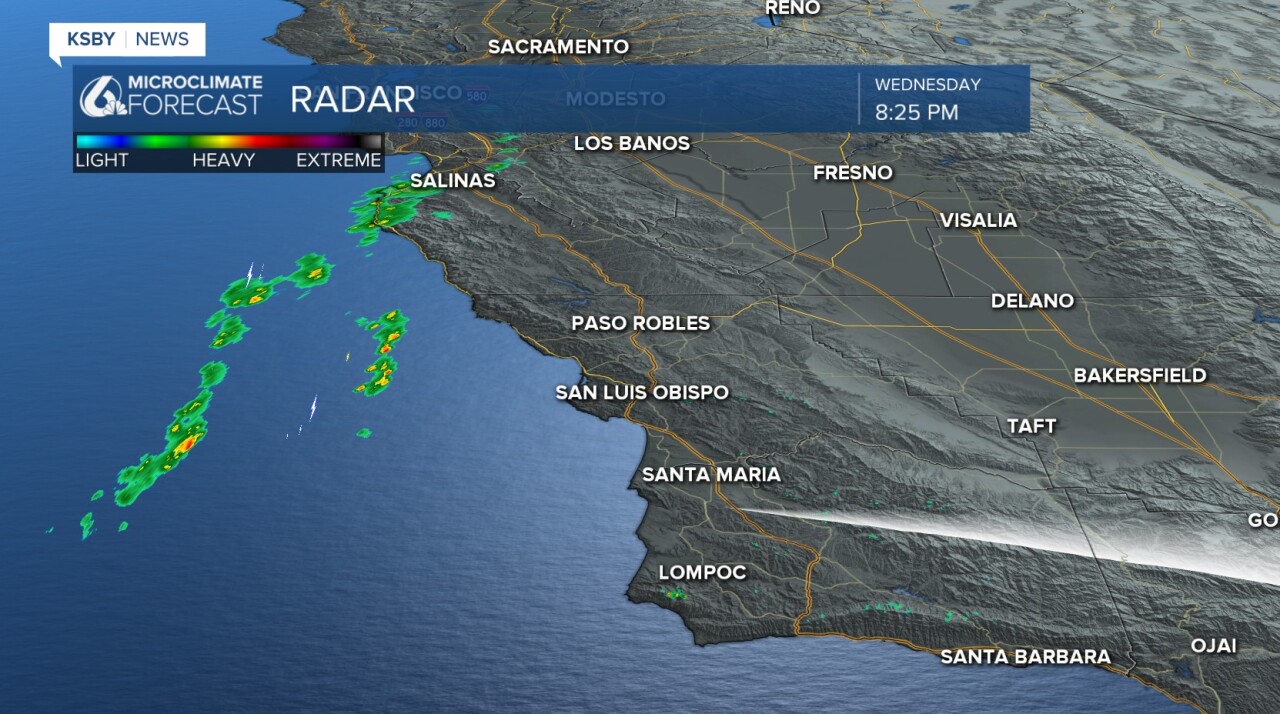
Already tonight the first few storms are nearing the north coast. Here is a look at the radar as of 8:25 p.m.
Check out the current interactive radar here!
This is all thanks to a broad trough of low pressure that is moving east towards California. The core low-pressure system will track over the Central Coast on Thursday and continue to bring us rain into the weekend.

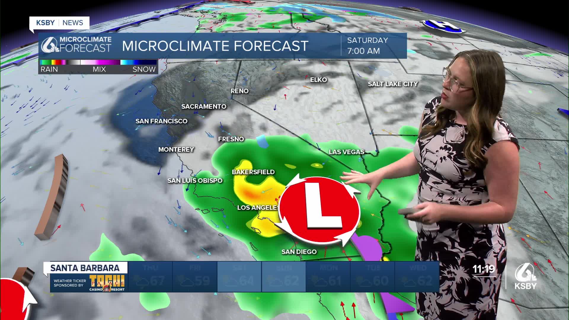
Let's time out the system. The low pressure driving this whole system is a 'cut-off-low', which means for us is that there are several rain chances (see below) and a massive amount of uncertainty.

The first showers will be mild and move through tonight into early tomorrow morning. This will just be an appetizer for the cold front that will reach us by early afternoon. When the cold front pushes through, we can expect a band of heavy rain and strong winds. The band will slowly move south and spread out into the evening.

By midnight, the storm will have moved south but will still be bringing heavy rain to the region. The difference between this and the core cold front is that the showers will be a bit less uniform and more widespread.

Friday will start off with more rain for the commute, but it will taper off through the morning.

Friday will be mostly clear with a few lingering showers possible. I have kept rain on the 7-day icon, but on the whole it will be light.
Saturday morning, the cut-off low pressure will wander back into the region. This is where more uncertainty comes in. This second band of rain will move in from the east, opposite from the first band.

This will linger through much of the day. On Sunday, there is also a chance for more of the lingering showers. I am keeping a very close eye on Sunday for the City to Sea runners.
Monday, another cold front will surge in and bring us another round of rain.
As you can tell, that is a lot of rain is headed our way. Plus, there is a lot of uncertainty tied to it. Here is what we can expect from now through Sunday morning. I think this model is a little on the light side, particularly for the highest peaks.
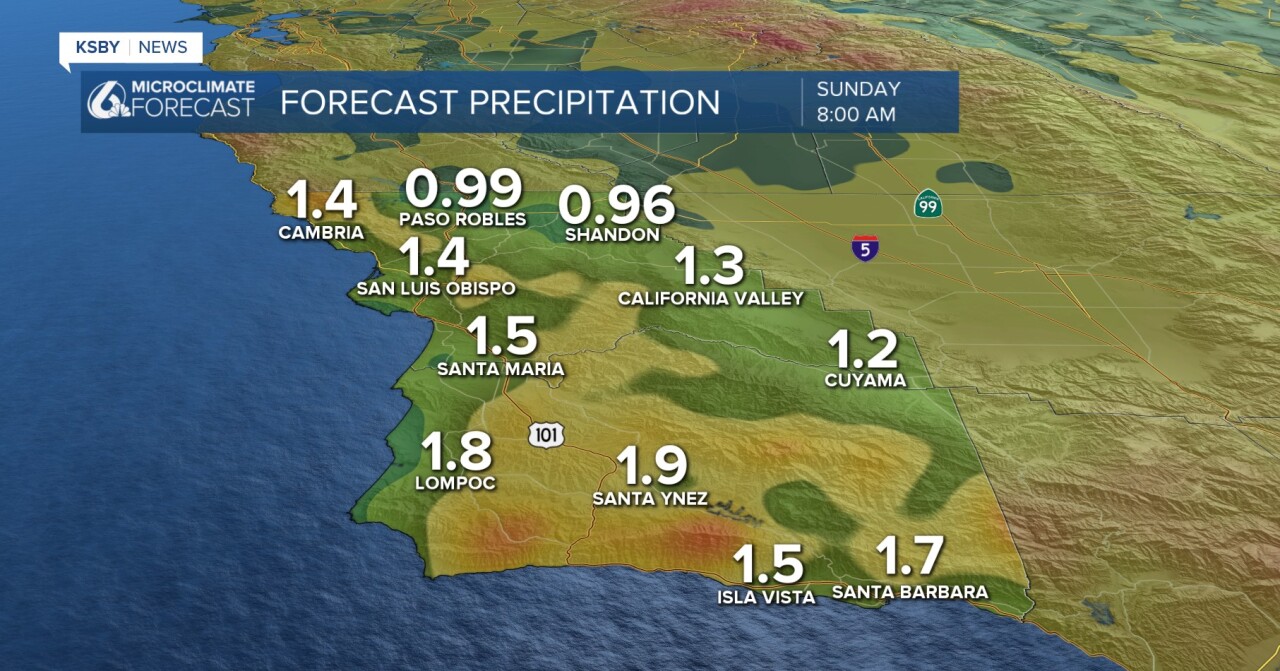
When you add in early next week and look at some of the more robust models, totals may be as high as 5 inches of rain over the next 6 days.
This model shows those totals, while this is more robust than what I expect it is my "prepare for the worst" scenario.

As a quick note, due to the rain in the forecast, the Thursday Downtown SLO Farmers' Market has been canceled.
Flooding of roadways and wildfire burn scars is possible.
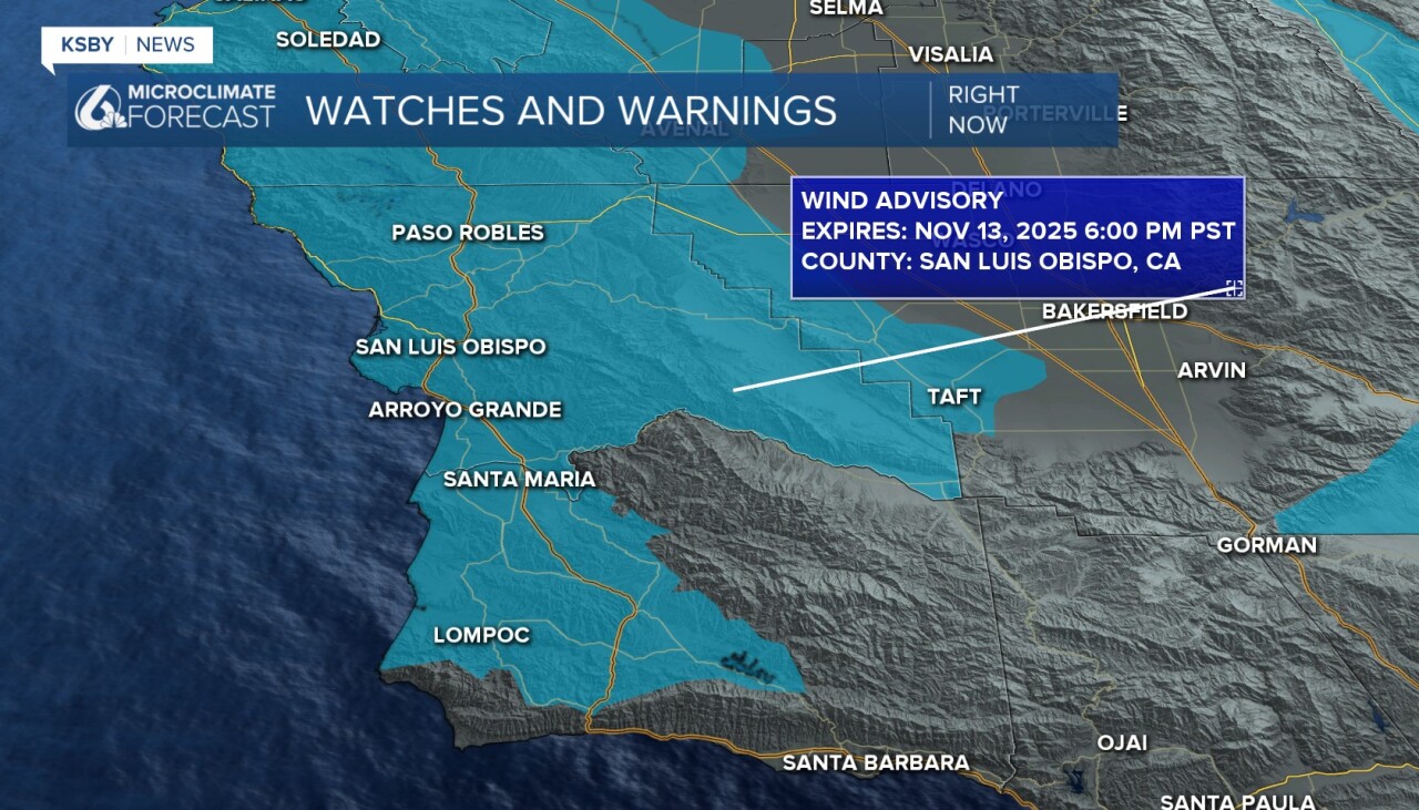
There are a few alerts already in place, starting with a wind advisory. This is in place from 8 a.m. to 6 p.m. on Thursday for San Luis Obispo County and Santa Barbara County, excluding the South Coast. Winds 20-30 mph with gusts up to 45 mph are expected.
There is also a high surf advisory in place for the western beaches through Saturday morning. Expect large breaking waves of 8 to 12 feet with local sets to
14 feet. Dangerous rip currents are expected too.

Now that that is out of the way, here is a look at the quick nuts-and-bolts of the forecast.

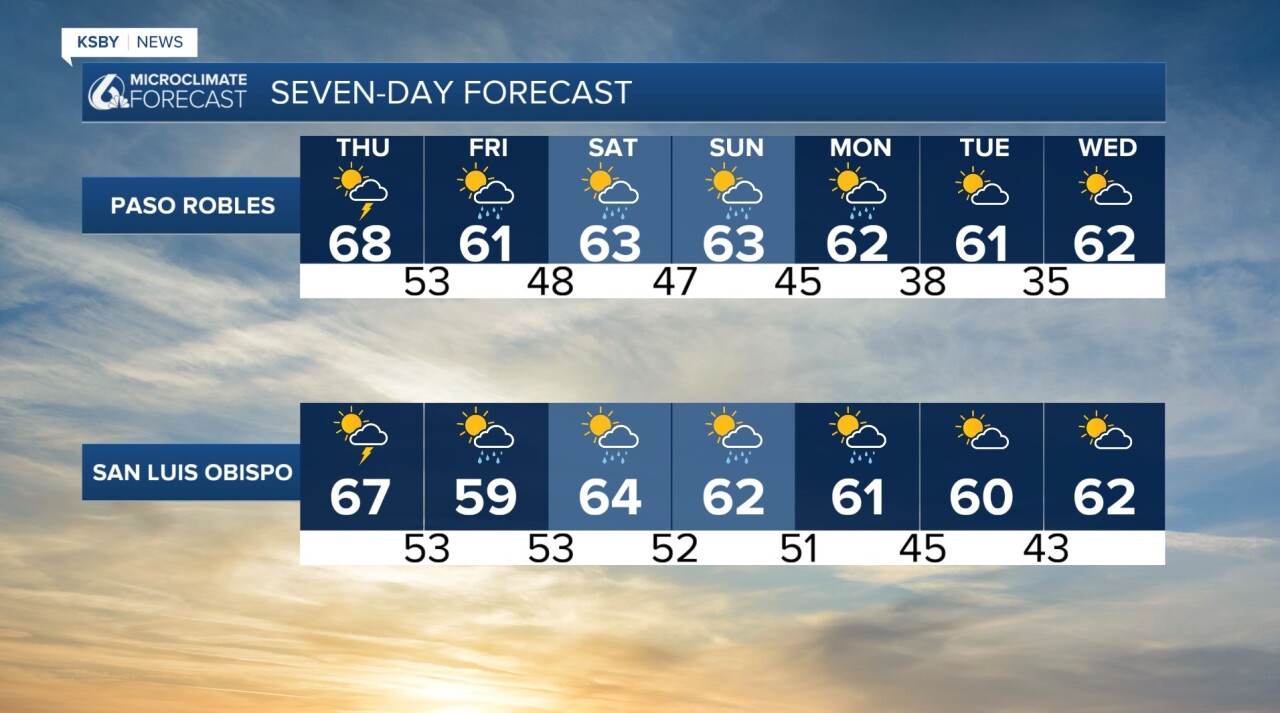
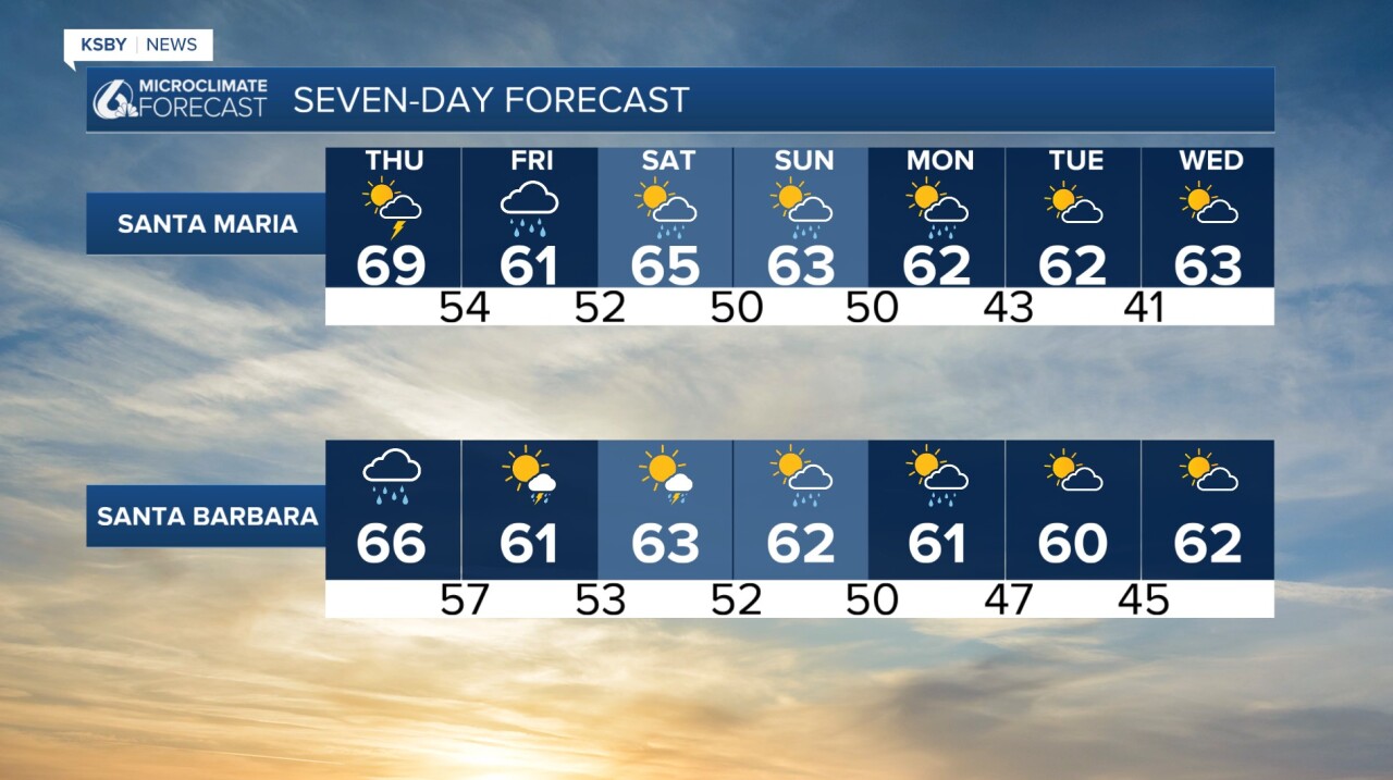
Here is the 7-day forecast!
I will keep you updated online and on air through the storm.
-Vivian
