


Good Wednesday evening, Central Coast!
The map below has all of the bigger fire updates, the containment percentage, and the number of acres burned. The Foothill Fire has expanded to 904 acres.

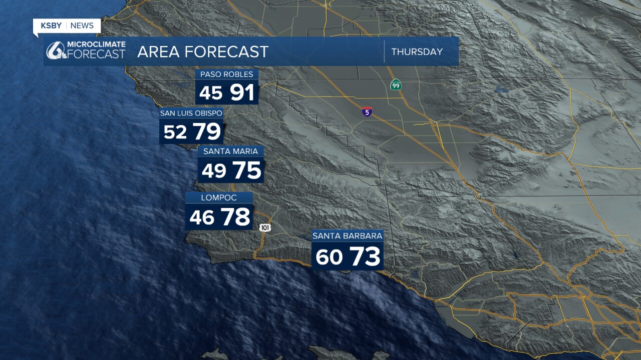
TODAY (HIGHS) NORMALS
SAN LUIS OBISPO 81 48/72
SANTA BARBARA 77 52/69
SANTA MARIA 77 49/69
PASO ROBLES 92 47/82
Tonight through Thursday: A weak upper-level trough will be moving across the Central Coast tonight and Thursday, marking the beginning of a significant weather pattern change. This system will initiate the return of onshore flow and cooler temperatures that our region hasn't seen in recent days.
Marine Layer and Fog Development: The most notable change for coastal residents will be the return of night and morning low clouds and fog. This marine layer will first develop along the immediate coastline tonight, then gradually work its way inland. By Friday, expect these low clouds and fog to reach areas south of Point Conception in Santa Barbara County, and by the weekend, the marine layer will likely penetrate the inland valleys of both counties.
Temperature Trends: Thursday will bring the first noticeable cooling, especially along the coast and in areas near the Santa Lucia Mountains and Santa Ynez Mountains. Coastal areas will see the most dramatic change, dropping several degrees from today's readings. The inland valleys, including areas around the Los Padres National Forest, will experience at least a few degrees of cooling, though the far interior sections will maintain today's temperatures for one more day before the cool air mass reaches them on Friday.
Weekend and Beyond: By the weekend, temperatures across San Luis Obispo and Santa Barbara counties will settle within a few degrees of normal for late May. Looking ahead to next week, expect temperatures to run 5 to 10 degrees below normal as the marine influence strengthens.
Extended Outlook: Very typical May weather will dominate the 4-day extended period. An upper-level trough pattern will cover most of California, bringing moderate to strong onshore flow to eastern areas and weak to moderate onshore flow to northern sections. This will generate a substantial marine layer with night-through-morning low clouds across most coastal areas and many valley locations daily.
Wind Patterns: Afternoon sea breezes will be stronger than normal due to the enhanced onshore flow. The western portion of the Santa Barbara south coast should expect varying degrees of north winds each evening. However, models have backed off earlier forecasts of increasing northerly flow across southwest Santa Barbara County, so significant Sundowner wind events are not expected through at least the weekend.
Daily Temperature Expectations: Most areas will cool 1 to 2 degrees each day, with Tuesday potentially seeing 2 to 4 degrees of cooling. Coastal areas can expect maximum temperatures in the mid-60s to mid-70s, while valleys will see upper 70s to lower 80s. This puts coastal and valley temperatures a few degrees below normal, while mountain areas and the far interior may run slightly above normal.
Marine Layer Strength: Due to the strength of the onshore flow, some beaches may remain socked in with marine layer clouds throughout the day, particularly areas facing west and northwest.

Below: May Gray working into coastal areas and some inland valleys over the holiday weekend. Cooler


Have a good night, Central Coast!
-Jim
