


Good Tuesday evening, Central Coast!
Here's the forecast for San Luis Obispo and Santa Barbara Counties:
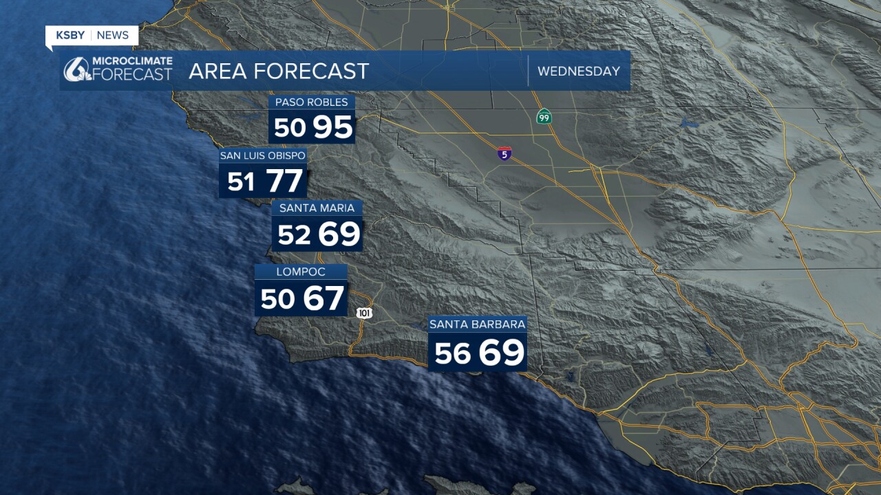
Below were the high temperatures on Election Day June 2nd, 2026.

THE BIG PICTURE: A ridge of high pressure will dominate our weather pattern through Thursday before weakening on Friday. This setup brings mostly clear skies in the afternoons but creates the perfect conditions for gusty winds - particularly the infamous sundowners that our mountain communities in Santa Barbara County.
Northerly offshore winds will be the headline through midweek. High-resolution forecast models show pressure gradients steadily increasing through Wednesday night, especially across the Santa Ynez Mountains. The usual suspect areas - those north-facing slopes and canyons in the Santa Ynez Range - can expect gusty conditions tonight and Wednesday night. While we're not expecting widespread advisory-level winds, localized wind advisories are definitely possible on Wednesday night.
Below: We have a Small Craft Advisory currently, a Gale Warning starts up at noon on Wednesday and goes until 9 am Thursday. Combined seas will be 11 to 15 feet.

Don't forget about our typical afternoon and evening southwesterly winds across interior valleys, the Santa Lucia Mountains and the Los Padres National Forest areas. These will continue their usual pattern during the warming hours of the day.
MARINE LAYER AND FOG: The marine layer will continue its nightly dance along our coastline. Tonight through Wednesday night, expect the usual low clouds and fog to develop after sunset and persist into the morning hours. The good news is that strengthening northerly winds will gradually push back the fog coverage through Thursday morning. However, Thursday night into Friday morning will see a bit more extensive marine layer development as conditions shift.
TEMPERATURE TREND: A warming trend is underway through Thursday as the upper-level ridge strengthens overhead and reduces marine influence. Expect temperatures to climb several degrees above recent readings. Friday brings a slight cooldown as the ridge begins to weaken and marine air makes a comeback.
WEEKEND AND BEYOND: Looking ahead, typical June weather returns this weekend. The upper-level ridge breaks down Saturday, replaced by a trough Sunday into next week. This means more persistent marine layer conditions with extensive fog coverage and the possibility of some drizzle. Early next week, northerly flow may reduce fog coverage somewhat, but expect mostly cloudy to partly cloudy skies.
Weekend temperatures will drop noticeably with the incoming trough and stronger onshore flow, though readings will remain near seasonal averages. Next week brings a modest rebound of a few degrees, but no significant heat is expected.
The bottom line: mostly pleasant June weather continues, with the main concern being gusty winds in our typical wind-prone areas. No significant weather systems threaten the region through early next week.
Below: The high-pressure ridge weakens Friday into Saturday, expect temperatures to cool a bit for the weekend.

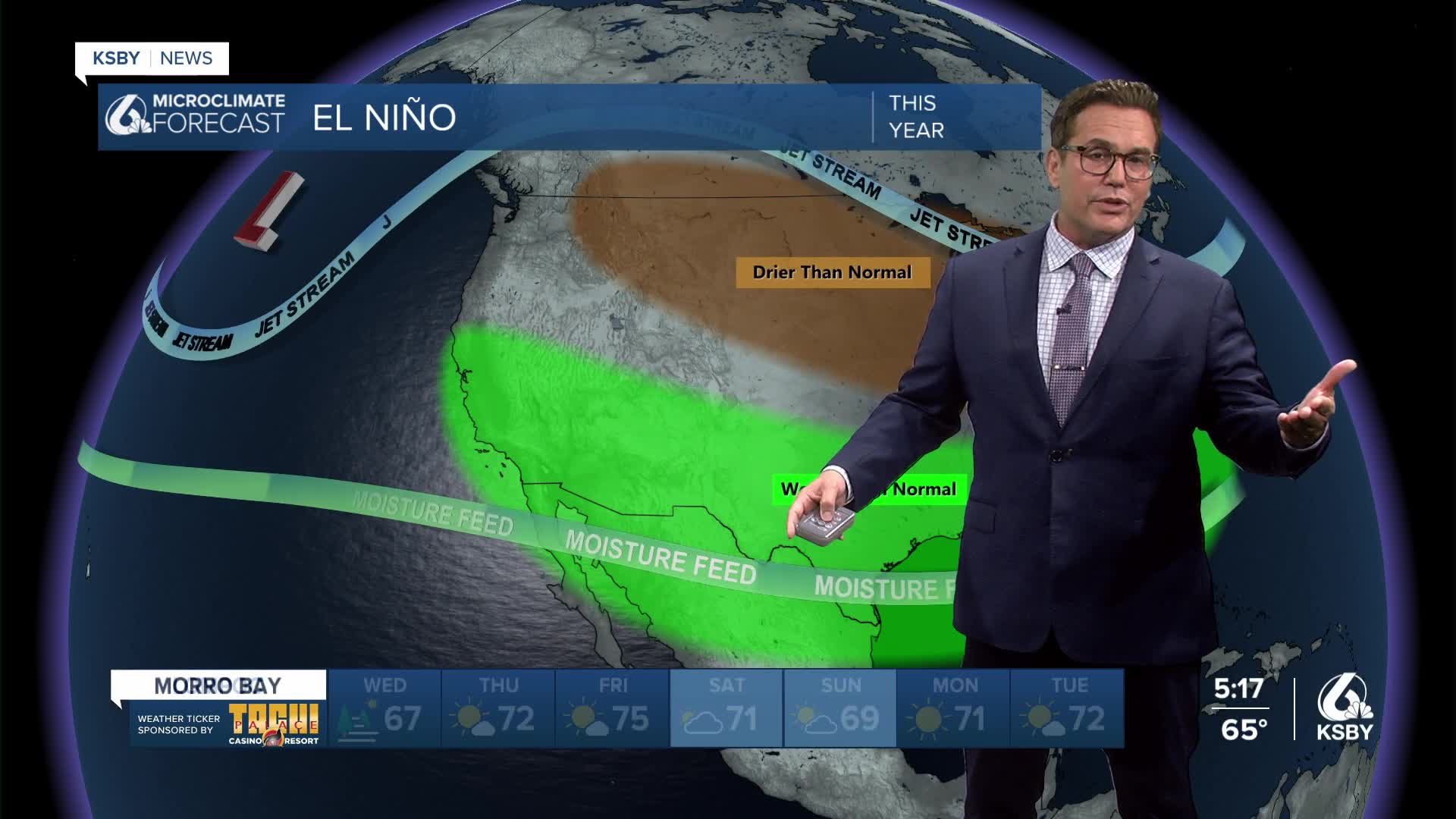
Side Note and an update on El Niño: Based on the World Meteorological Organization's announcement, June 2nd, an El Niño event is arriving with alarming certainty this summer and is expected to persist through autumn and potentially into winter. With an 80% likelihood of developing between June and August, and a 90% chance of continuing through November, this climate phenomenon represents an urgent warning for global communities. The WMO emphasizes that El Niño conditions will act as "fuel on the fire" of our already warming planet, amplifying extreme weather impacts that will hit harder, spread farther, and cross international borders with devastating speed. For the Central Coast, this means likely wetter-than-average conditions as the subtropical jet stream becomes supercharged, steering Pacific storm systems directly toward the region. Combined with ongoing climate change, this El Niño could drive temperatures to record-breaking levels, potentially making 2027 the hottest year on record, while triggering more frequent and intense droughts, floods, heatwaves, and storms across the globe.


Have a great night, Central Coast!
-Jim
