


Good Monday evening, Central Coast!
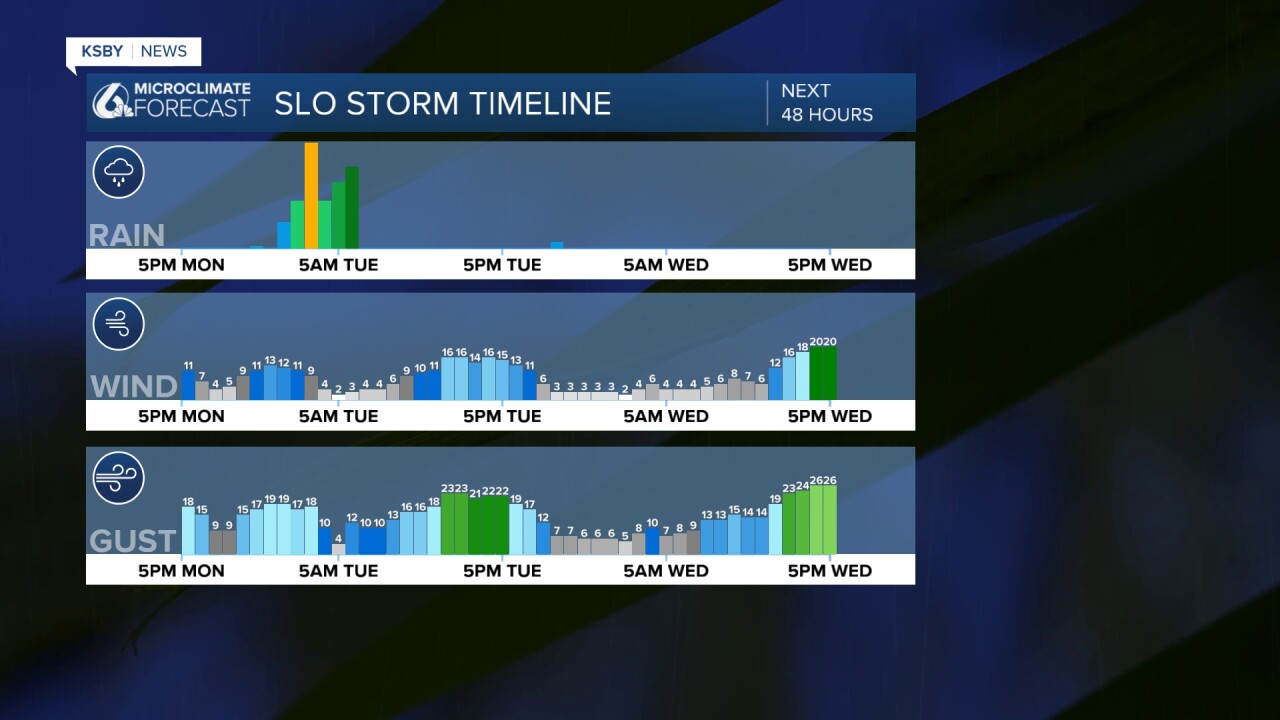
Light to moderate rain begins later tonight and continues through Tuesday. The main rain occurs Tuesday morning as a cold front moves through the region.

Below is the forecast rainfall potential from later tonight through mainly early Tuesday. It looks like .25" up to 1.00" is the range.

STORM SYSTEM APPROACHING THE CENTRAL COAST
A moderate April storm system is targeting our region, bringing the most significant impacts to San Luis Obispo County, with lighter effects expected in Santa Barbara County.
RAINFALL FORECAST San Luis Obispo County will see the heaviest precipitation with rainfall totals ranging from one-quarter inch to locally one inch. Santa Barbara County can expect similar amounts of one-quarter to one inch, with the highest totals likely in the Santa Ynez Mountains.
TIMING AND INTENSITY Light to moderate rain begins later tonight and continues through Tuesday. The main rain occurs on Tuesday morning as a cold front moves through the region. Peak rainfall rates will generally remain around one-quarter inch per hour, though brief periods of half-inch-per-hour rates are possible during thunderstorms or along the frontal boundary, especially in the Santa Barbara mountains, extending into far western areas.
THUNDERSTORM POTENTIAL: San Luis Obispo County has a slight chance of thunderstorms Tuesday, mid-morning through mid-afternoon, particularly in the Santa Lucia Mountains and Los Padres National Forest. These storms could produce brief heavy downpours, gusty winds up to 40 mph, and cloud-to-ground lightning.
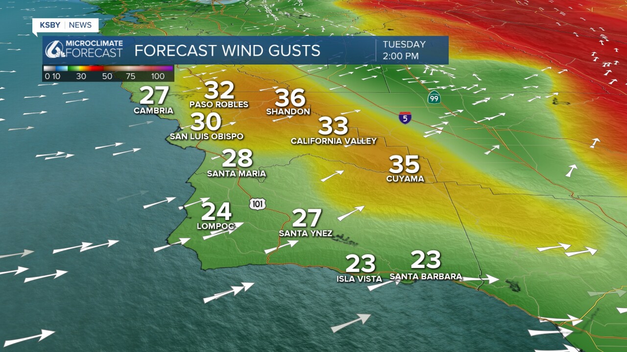
WIND CONDITIONS Gusty southwest winds of 20 to 40 mph are expected through Tuesday across both counties. Wednesday through Friday brings a shift to west-northwest winds, with advisory-level gusts of 30 to 50 mph possible late Tuesday through early Thursday. The Santa Lucia Mountains, Santa Ynez Mountains, and interior Los Padres National Forest areas will experience the strongest winds, though coastal areas may also see periods of gusty conditions.
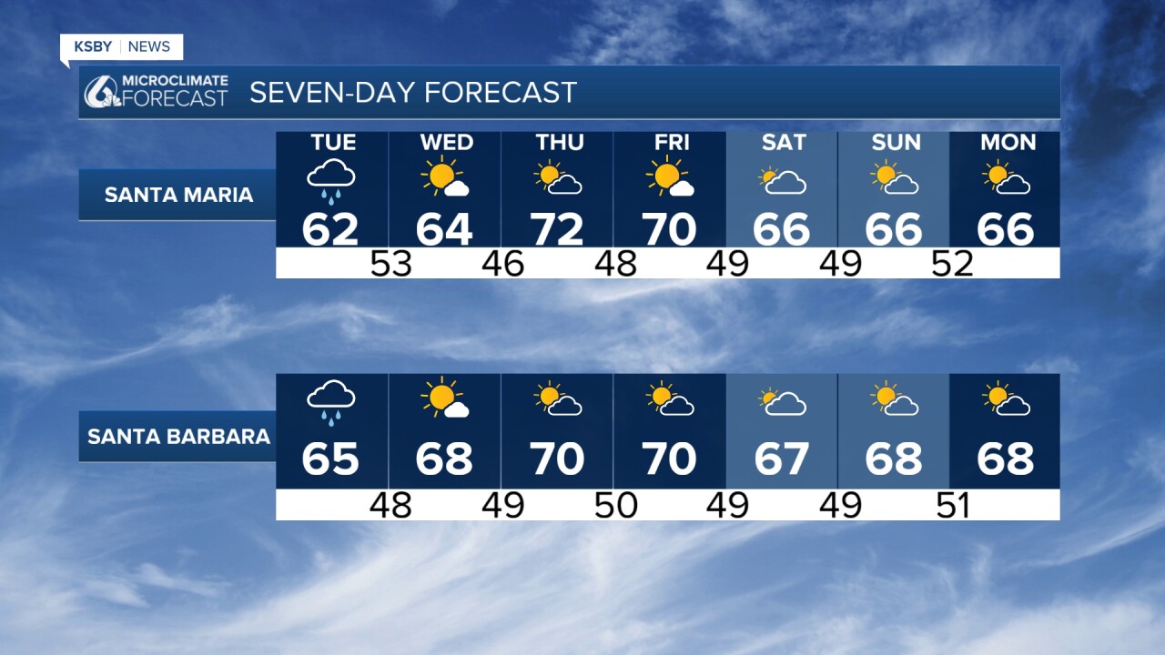
TEMPERATURE TRENDS A significant cooldown arrives Tuesday and Wednesday. Expect 60s behind the storm system and lows in the 40s.
EXTENDED OUTLOOK Friday brings near-normal temperatures with highs in the low to mid-70s. Weekend temperatures drop several degrees below normal, with highs commonly in the 60s. There's a 30 to 50 percent chance of mainly light rain across the foothills and interior areas this weekend, with another weak storm system possible early next week, continuing an active April pattern for the Central Coast.


Have the umbrella handy for Tuesday morning!
-Jim
