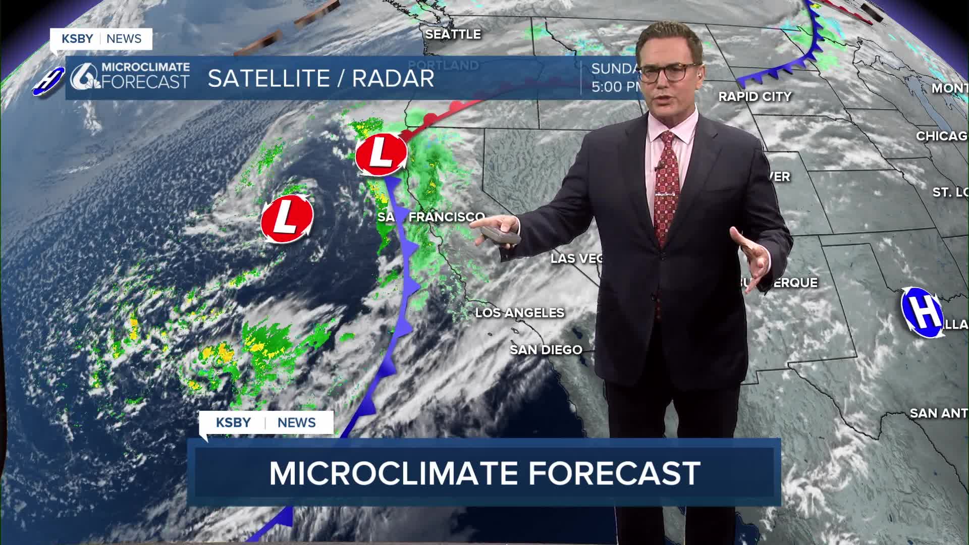


Good Sunday Evening, Central Coast!
All eyes are on our incoming Pacific storm, especially on Monday when a strong Pacific cold front is moving through the region:
• Central Coast: Shortly after dawn
• Santa Barbara County: Late morning
Expect a powerful, fast-moving system.
What to expect Monday:
Rainfall
• 1 to 2.5 inches for coasts and valleys the totals through Wednesday will likely be 2 to 4"
• highest in foothills and mountains
Rain rates
• Commonly 0.5 inch per hour
• Isolated rates over 1 inch per hour in thunderstorms, if your area has a thunderstorm
Winds
• 20–30 mph with gusts of 45–55 mph in coasts and in the valleys
• Mountain gusts up to 55 mph
Thunderstorms
• If you get a T-storm, intense rain is possible, and a 65+ mph downburst is possible
• A very slight chance of waterspouts or brief weak tornadoes
Hazards
• Tree damage from strong winds
• Roadway flooding and small stream flooding
• Debris flows are possible near recent burn scars, Gifford & Madre burn scars from 2025
mainly along Highway 166
By Monday evening, showers taper off. Tuesday morning looks mostly dry before a second system arrives late Tuesday
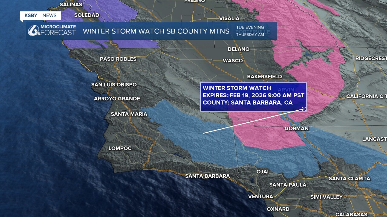
Storm No. 2 moves in Tuesday night into Wednesday. It will be colder but not as wet:
• 0.5 to 0.75 inches for most areas
• Higher totals in the mountains
• Snow levels could drop near 3,000 feet, possibly impacting major passes like I-5 through the Grapevine if you are traveling
Highs will stay in the chilly 50s. Rain gear and a heavy coat are needed!
Another fast-moving system may brush the area on Thursday, but confidence in rainfall is lower. Friday and Saturday look mostly dry with gradual warming, though temperatures remain below normal.
Below is a snapshot of Monday at 7 am with heavier rain in red and yellow with possible thunderstorms. We will also have very gusty south winds.

Below is the timeline for the heaviest rain during the morning commute to around noon. It will be a very gusty day on Monday.

A flood watch has been posted for most of Santa Barbara County from Monday morning until Monday evening. Any areas in San Luis Obispo County or Santa Barbara County could see flash flooding and ponding on the roads and highways. The Gifford and Madre burn scars could see rock and mud slides.

Below in blue is the wind advisory from 6 am until 6 pm on Monday. SW wind 20 to 30 mph with gusts 45 to 55 mph are likely.

Below is the High Wind Warning for the interior valleys of San Luis Obispo County and the mountains. This includes the interior mountains of Santa Barbara County 6 am Monday until 6 pm. Gusts to 55 mph are possible.

Below is the High Surf Advisory along the Central Coast and the South Coast from 10 am on Monday until 6 pm on Thursday. Large crashing waves of 10 to 15 feet will be common, with sets to 20 feet possible. A beach hazard statement has been issued for the Santa Barbara County coastline with the high risk for rip currents and rough water. Also, a Gale Warning has been issued from tonight at 10 pm through 8 am Wednesday. Combined seas of 14 to 17 feet will be common offshore.

The snow level drops to nearly 3,000 feet Tuesday evening through Thursday morning. A Winter Storm Watch has been posted for the Santa Barbara County mountains. 1 to 4 inches of snow are possible between 3,500 feet and 4,500 feet, and 6 to 12 inches above 4,500 feet with wind gusts to 50 mph. We are really watching the Big Pine Mountain area closely.
Below are the chilly high temperatures we will see on Monday. Grab your heavy coat with your rain gear!


Stay weather aware, Central Coast! The KSBY Weather Team will keep you posted!
-Jim
