


Happy Friday, Central Coast!
Here's your detailed Central Coast weather forecast for San Luis Obispo and Santa Barbara Counties:
The marine layer will be a dominant feature through next week, with stratus clouds and patchy fog developing each evening along the coast and pushing inland to the coastal valleys. This marine influence will expand deeper into valleys over the weekend and persist well into next week during overnight and morning hours, often lingering into early afternoon. Areas of mist and drizzle are possible.
Expect a gradual cooling pattern through Monday as persistent troughing over California maintains below-normal temperatures. After Monday, temperatures will stabilize but remain cooler than average through late next week.
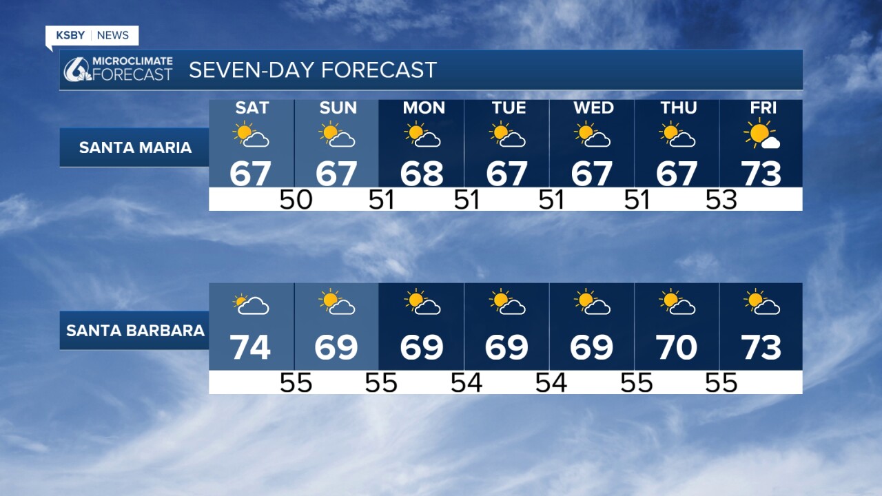
Beaches will see highs in the upper 50s to low 60s, coastal valleys mainly in the 70s, and far interior valleys may reach the low 80s.
Temperatures will trend back toward seasonal normals by next weekend as flow patterns shift.
Winds will increase this evening as the pressure gradient tightens, peaking Saturday.
WIND ADVISORIES are in effect for the Santa Barbara southwest coast and the Santa Ynez Mountains western range.
Sundowner winds are expected from 5 PM today through 3 AM Saturday, then again Saturday night into Sunday morning with NW winds 15-30 with gusts 45 to 50 mph.
A secondary low-pressure system will drop into northern California early Monday, rotating southward before lifting northeast into Nevada by early Tuesday. The persistent trough over California will maintain onshore flow, continuing the daily marine layer pattern.
While no significant precipitation is forecast, very light mist or drizzle from the stratus deck remains possible. The pattern shifts late next weekend as flow becomes more zonal and high pressure builds over the Southwest.
This stable pattern offers predictable conditions for outdoor activities, with morning marine layer clearing to partly cloudy to sunny afternoons inland.


Have a great weekend, Central Coast!
-Jim
