


Good Thursday evening, Central Coast!
Gorgeous Morro Bay photo by Cyndi Kostecka! I'll be going live from Morro Bay tomorrow - catch me at 4, 5, 6, and 6:30 pm.
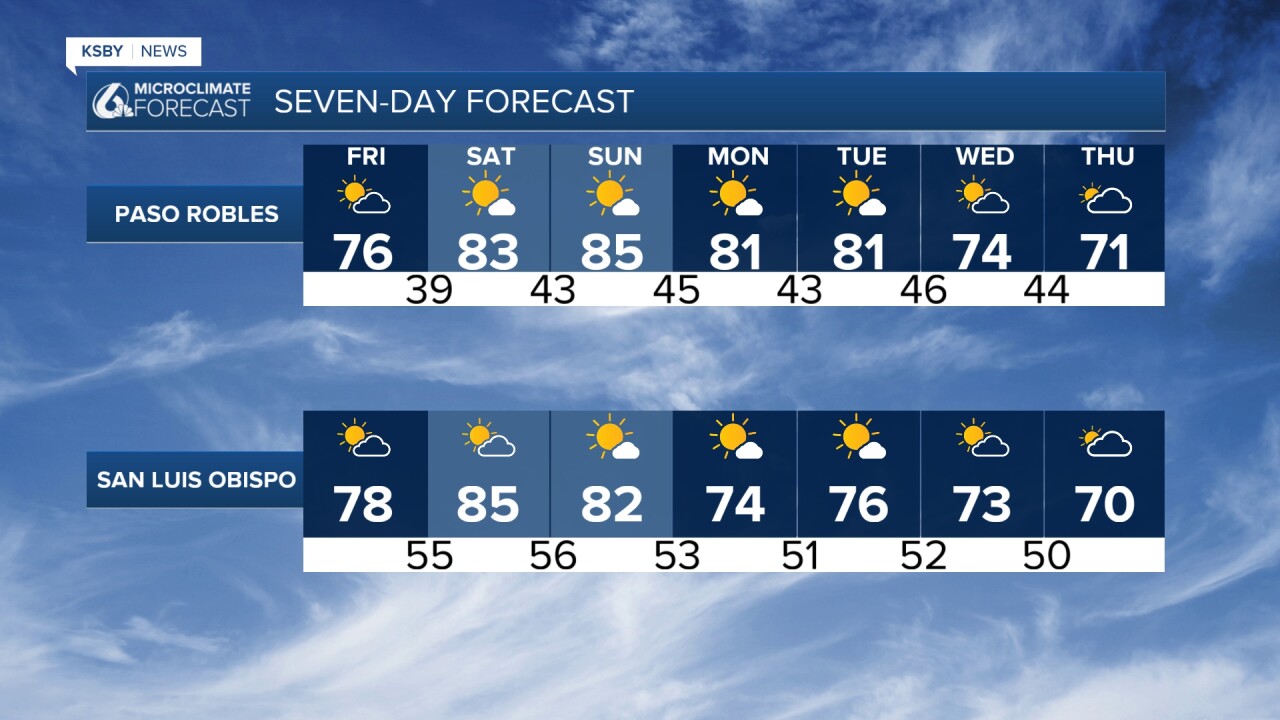
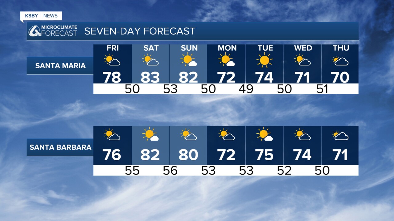
Weekend forecast: Gusty and warmer Friday-Sunday: 5-10 degrees warmer each day Saturday: 70s for the coast and 80s in the valleys (10-15 degrees above normal!)
Sunday: Offshore to onshore transition with some coastal cooling. Breezy offshore winds Sunday morning, but much calmer than Fri-Sat. Perfect beach and outdoor weather ahead!
More weekend forecast details:
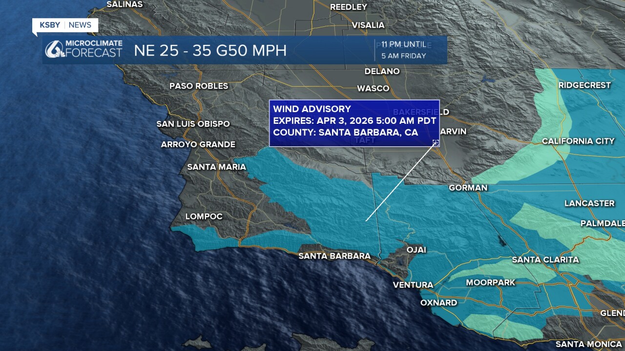
SIGNIFICANT WARMING FRIDAY THROUGH SUNDAY as gusty offshore winds return to the Central Coast. Sundowner winds will be strongest on Friday and Saturday across Santa Barbara County, with Santa Lucia winds also developing across San Luis Obispo County. A cooling trend will begin Monday, with temperatures returning to near-normal around midweek.
SHORT TERM (NOW THROUGH SUNDAY)
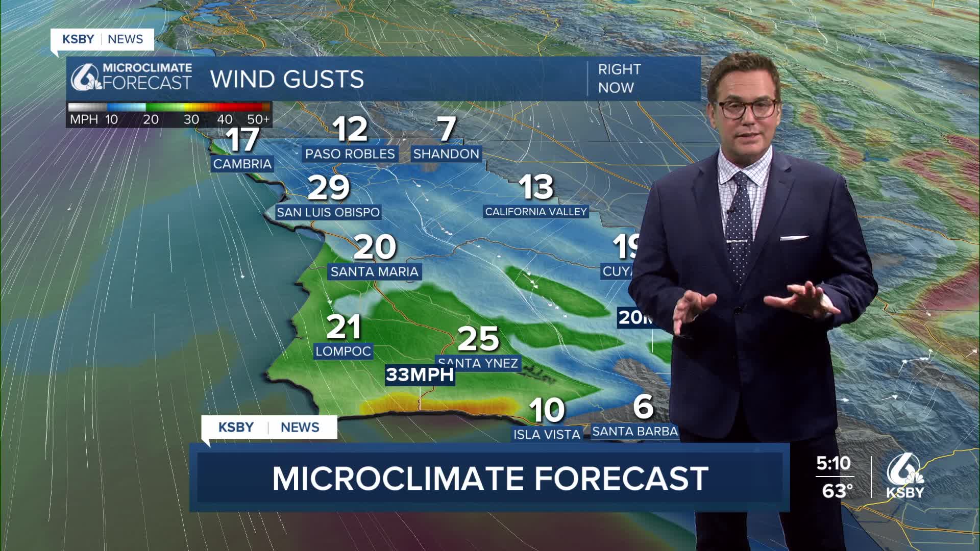
Winds and warming temperatures will dominate the weather pattern through at least Saturday as offshore winds return to the Central Coast. Tonight, winds will turn more northeasterly, focusing in the mountains and interior valleys of both counties.
Friday morning, winds will shift to the northeast, bringing moderate to locally strong Sundowner winds to Santa Barbara County that will last through at least Saturday. The pressure gradient shows an impressive shift from 6mb onshore flow today to 6mb offshore flow Friday morning - a 12mb change in just 24 hours.
Upper-level winds around 40-50 knots will produce:
- Santa Barbara County: Widespread 30-50 mph Sundowner winds in favored areas, with local gusts to 60 mph in the Santa Ynez Mountains and passes
- San Luis Obispo County: Santa Lucia winds likely across the Santa Lucia Range, mainly Friday, though most areas will remain below advisory levels
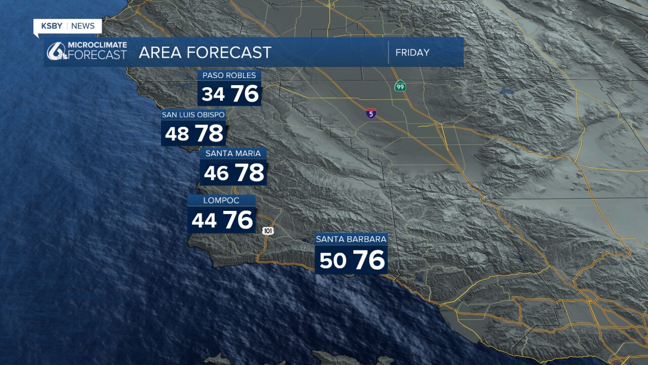
Temperature Outlook: Rapid warming is expected across the region, except on the higher peaks. Look for 5-10 degrees of warming both Friday through Sunday.
By Saturday:
- Some coastal and all valley areas will reach the 80s
- Temperatures will be 10-15 degrees above normal (though no records expected)
Sunday will see offshore flow transitioning to onshore, bringing some cooling to the coast but keeping inland areas warm. Expect locally breezy offshore winds Sunday morning, but much weaker than Friday-Saturday.
LONG TERM (MONDAY-THURSDAY)
With onshore flow returning next week, coastal and valley temperatures will cool down. However, building high pressure aloft Tuesday and Wednesday will maintain temperatures 3-6 degrees above normal through mid-week.
For the second half of the week, models show an approaching trough that could bring light rain as early as Wednesday night or as late as Friday, but most likely Thursday or Thursday night. Rainfall amounts look light at this point
Warm Saturday and Sunday, partly to mostly sunny.

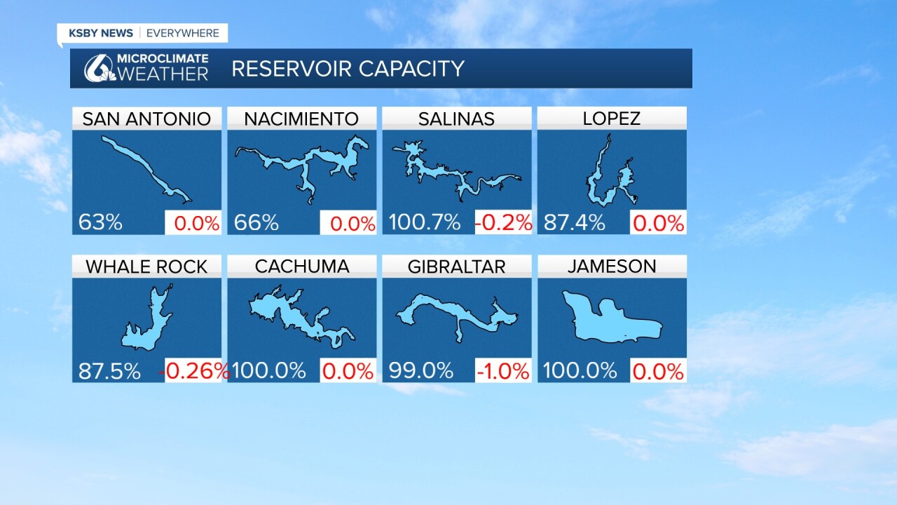
It's Thursday, so here are our Reservoir levels.
Have a great night, Central Coast!
-Jim
